Index par titre
Information for In App Purchases via Apple
- Payment will be charged to your iTunes Account at confirmation of purchase.
- Subscription automatically renews unless auto-renew is turned off at least 24-hours before the end of the current period.
- Your account will be charged for renewal within 24-hours prior to the end of the current period. The cost of the renewal will be the same as the cost of your initial transaction.
- You can manage your subscriptions and auto-renewal may be turned off by going to your Account Settings after purchase.
What is a community?
A community allows you to gather users around a theme, a person, a sport or just a particular passion.
When your community is created, you are given the opportunity to post trails and points of interest on behalf of the community.
It is also possible to appoint different administrators and contributors to help you feed or administer the community.
How to communicate with other Sitytrail members?
Article in progress.
How to create a community?
1) Once connected, go to "network - Communities".
2) Click on "create a community".
3) Fill in the fields to create your community.
4) Make sure to click on "validate my request" so that your community is created.
Note: It is possible to define different visibility status of a community: public or on acceptance only. When you post content in the community, you decide whether it's visible to everyone, or only by your members or contributors.
Is the creation of a community immediate?
The creation of a community is not immediate.
In order to preserve the quality of the contents and communities proposed, your request for creation must be examined by a member of our team before being accepted.
This operation can take between 1 and 3 working days.
How to discover a specific community?
1) Go to the "network - Communities" section.
2) Once in this one, click on the "find  " tab at the top right of your screen.
3) Enter in the search bar the name of a community, activity or place that interests you to find a specific community.
4) From there, it is up to you to select the community that suits you best among the proposed communities.
How to follow a Sitytrail member?
Article in preparation.
How to join a community?
1) Go to "network - Communities".
2) From there, select the tab "Communities" which will allow you to arrive on a page showing the various communities of the site.
3) You are then invited to select the community that interests you.
4) To join this one, click on the "ask to join" tab.
How to manage my communities?
1) Go to "network - Communities".
2) From there, you can manage your communities, find members, ...
How to search after another Sitytrail member?
Article in preparation.
How to create a trail?
1) Once logged in, click on "create a trail".
2) Select the draw mode you need (manual, automatic).
3) Click on "draw".
4) Draw your trail point by point.
5) Once your trail is over, click on "save".
6) Finally, describe and publish your trail.
How to cut a plot?
1) Once the trail has been drawn and saved, click on the "Operation" tab.
2) Select the "split the track" proposition.
3) Once done, place the cursor on the places you want to cut.
4) When finished, click on "finish cutting".
5) Following this, you will be offered to "delete the selected part" or "create a new trail" with it.
6) Select the proposition that interests you.
7) Make sure you click "ok" to confirm your choice.
How to delete points in a trail area?
Article in preparation.
How to describe and publish a trail?
1) Create a trail.
2) Once the trail has been created, click on the "describe and publish" tab.
3) From there, you will be asked to fill different fields.
4) When you have completed all the fields proposed, without forgetting to enter the outdoor activity, make sure you click on the "register" tab.
Note: if you click on the "save" tab you will return to the map with your track while clicking on the "save and finish" tab will return you directly to the "dashboard" heading.
How to change the display of my trails?
Two options are available to you :
Change the display options in the editor:
1) Go to the "settings".
2) Select the "display" proposition.
3) Once done, go to the editor section.
4) Change the different display options.
Change display options when creating a track:
1) Go to "create a trail".
2) Click on the "display" tab.
3) Then change the different display options.
How to draw a trail?
1) Go to "create a trail".
2) Enter a start point in the search bar at the top left of your screen.
3) Once done, select the draw mode.
4) Then click on the "draw" tab.
5) Then go to the map and point your cursor at the starting point of your trail.
6) Trace your trail point by point.
7) When you are done, choose the "describe and publish" tab.
How to change the draw mode your trail?
1) Once connected, go to "create a trail".
2) Once you are on the map, select the "draw mode" tab.
3) Click on the desired automatic mode.
4) The chosen mode will be displayed in blue and from there, it's up to you!
How to import a GPX?
1) Once connected, go to "create a trail".
2) When you are in this topic, click on the "operation" tab.
3) Select the proposal "Import GPX".
4) Follow the instructions.
How to change the map when creating a trail?
Once you find yourself on the "create a trail" part of the site,
1) You have the possibility to choose the map on which you will create your trail.
2) To do this, click on the tab "map selection" at the top right of your screen.
3) Select the map on which you want to draw your trail.
Notes: different types of cards ...
How to modify a trail?
To modify,
1) Click on the "edit" tab.
2) Change your draw mode (you must be in manual mode to modify).
3) Modify the trail using the points on the track.
If you want to modify by after,
1) Go to your "dashboard".
2) Click on the trail you want to edit.
3) Display it in a large screen using the arrows in the upper right corner of the hike **.
4) Then click on the "edit" icon  .
.
5) Select a proposal.
6) Modify as you want.
Note: Remember to save your trail after any changes.
How to look for a specific place for the creation of a trail?
Once you find yourself on the "create a trail" part of the site,
1) Click on the "location search" bar at the top left of your screen.
2) Enter the name of the desired place.
3) Select one of the displayed proposals.
How to create points of interest?
Two options are available to you.
Via the track of the trail:
1) Click on the "points" tab  .
.
2) Select "+ new point of interest".
3) Click on the location of the POI or search for a location via the search bar.
4) Click on the "description" tab to add more information and photos on this point of interest.
5) Be sure to record the point of interest once you have finished validating the previous steps.
Via "create a place":
1) Go to "create a place".
2) From there, find the location of the point of interest using the search bar.
3) Then fill out the proposed fields without forgetting to insert photos so that your new point of interest is as attractive as possible.
Note: Compared to the track, it is necessary for the trail to be saved before creating points of interest.
How to print my trail?
Two options are available to you.
1) Once your trail is created and saved, print it by clicking on the "Operation" tab and selecting the "Print" option.
2) You can print your trail by going to the "dashboard".
- From there, select the trail you want to print.
- Click on it to get the details of it.
- Finally, once on the description of your trail, click on the icon "print" **.
How to reverse the direction of the trail’s track?
1) Once your trail has been drawn and saved, click on the "Operation" tab.
2) Select the "reverse the route " proposition.
3) Then follow the instructions.
How to save your trail?
1) When you are creating your trail, click on the "save" tab.
2) From there, your trail will automatically register.
Note: Remember to save your track as you progress.
How to make the slopes visible on the map when creating a trail?
1) Go to the "create a trail" part of the site.
2) From there, you have the possibility to make appear the slopes on the map thanks to the cursor present at the top of this one.
Notes: The appearance of slopes varies depending on the position in which you place the cursor.
If you drag the slider all the way to the left, the slopes do not appear while if you move the slider all the way to the right, the slopes appear to the maximum.
Attention, so that these slopes are visible, it is necessary to zoom a minimum on the map.
How to make my trail public or private?
Two options are available to you.
1) Once you have created your trail, and you are in the "describe and publish" section of your trail, choose the "me only", "everyone" or "community member" mode, in the "visible by" tab.
2) Once your trail is recorded and published, go to your "dashboard", click on "see the table" in the "my trails" section.
Then select the "Settings" icon  of the trail you want to edit. From there, you can change the status and choose the desired visibility mode by clicking on either the "move to private status" or the "move to public status" proposal.
Note: If the eye that describes your trail is green, your trail is in public mode, while a ruled red eye represents the private mode.
How to search trails from the GPS position?
1) Once on the app, go to the "Trail discovery" section. 
2) Press "Displayed relative to" at the top of the screen
3) Select "From GPS position".
4) Once it's done, check out the premium catalog and all the nearby trails will be displayed.
Note: If you want to refine the search by activity, you can click on the activity at the top of the screen and you can choose the one required for the desired trail.
How to discover a trail via the app?
Once on the app, go to the "Trail discovery" section. 
From there, three possibilities are available to you to find a hike.
From the GPS position:
1) Press "Show as" at the top of the screen
2) Select "From GPS position".
3) Once it's done, check out the premium catalog and all the nearby trails will be displayed.
From the chosen position on the map:
1) Go to the map section.
2) Choose a place to discover the trails.
3) Then, return to the discover part.
4) Press "Show as" at the top of the screen by selecting "From the center of the map".
5) Once done, discover the premium catalog and all the nearby trails will be published.
From a QR Code:
This is the first button at the top of your screen, it allows to scan a SityTrail QRcode present on a PDF print realised from our Website.
A lot of SityTrailPro clients, or also communities, proposed offer paper maps in A4 OR a3 format with hikking suggestions.
Scan the QRCode frome the paper map allow to open directly the selected trail in the mobile application. Let's go to discover the region !
Note: If you want to refine the search by activity, you can click on the activity at the top of the screen and you can choose the one required for the desired trail.
How to display the date of the trail ? 
How to download a trail ? 
1) Look for a trail.
2) Press the trail you want to download.
3) The details of it will be displayed in large and then press the "Download" icon  in the bottom right-hand corner of the screen.
How to download a trail from the catalog?
1) Look for a trail.
2) Press the trail you want to download.
3) The details of it will be displayed in large and then press the "Download" icon in the bottom right-hand corner of the screen.
How to add a trail to his favorites ? 
1) Look for a trail.
2) Press the trail you want to add to favorites.
3) The details of it will appear in large and then press the icon "Add to favorites" 
How to add a trail to favorites?
1) Look for a trail.
2) Press the trail you want to add to favorites.
3) The details of it will appear in large and then press the icon "Add to favorites" .
How to filter trails catalog by criteria ? 
1) Press the "Filter" icon at the top of your screen.
2) Choose the different criteria you want to apply to filteryour research.
You can filter by :
- Proximity,
- Reference point,
- Activity (you can choose the type of activity, the difficulty and also th duration of the activity),
- Length
- Rating.
How to filter catalog trails by criteria ? 
In construction ...
How to add a trail to a list ? 
1) Look for a trail.
2) Press the trail you want to add to a list.
3) The details of it will appear in large and then press the icon "Add to a list" 
4) Once done, choose the list in which you want to store the trail.
How to add a trail to a list?
1) Look for a trail.
2) Press the trail you want to add to a list.
3) The details of it will appear in large and then press the icon "Add to a list" .
4) Once done, choose the list in which you want to store the trail.
How to search trails from a chosen position on the map ?
1) Once on the app, go to the "Trail discovery" section.
2) Go to the map section.
3) Choose a place to discover the trails.
4) Then, return to the discover part.
5) Press "Displayed relative to" at the top of the screen by selecting "From the center of the map".
6) Once done, discover the premium catalog and all the nearby trails will be published.
How to search trails from a certain position ?
1) Once on the app, go to the "Trail discovery" section.
2) Press on the first button at the top of your screen
It allows to scan a SityTrail QRcode present on a PDF print realised from our Website.
A lot of SityTrailPro clients, or also communities, proposed offer paper maps in A4 OR a3 format with hikking suggestions.
Scan the QRCode frome the paper map allow to open directly the selected trail in the mobile application. Let's go to discover the region !
How to look for a trail or a point of interest?
1) Once connected, go to "discover".
2) You then have the choice to search after a trail or point of interest.
If you are looking for a trail,
1) Encode a city, a locality in the search bar.
2) Select an outdoor activity to find the trail that's right for you.
3) From there, a series of trails are proposed to you and it is up to you to make your choice.
If you are looking for a point of interest,
1) Encode a city or town.
2) Select the category of the point of interest you are looking for.
3) From there, a series of points are proposed to you and it is up to you to make your choice.
What does the notion of altimetric profile represent?
The altimetric profile allows you to have a vision of different altitudes that you will encounter during the trail. Thanks to this one you can easily determine the difficulty or the ease of the trail.
How to get the trail's details ?
1) Find the trail you are interested in.
2) When you think you have found the right trail, click on it to see details such as altimetry profile, mileage, QR code, etc.
You are therefore on the description sheet of the trail.
How to export a trail in GPX format?
Three possibilities are available to you:
1) Go to your "dashboard".
Click on the icon  to the left of the trail you want to export.
Then select the "download GPX" option.
2) Go to your "dashboard" and open the trail you want to export.
From there, click on the "download" icon  and choose the "Download GPX" option.
3) Go to your "dashboard" and open the trail you want to export.
Once on its description card, open the trail in large format by clicking on the cross at the top left of it**.
Once on the map, click on the "download" icon and choose the "download GPX" option
How to add a trail of the catalog in his favorites?
1) Find the trail you are interested in.
2) When you think you have found the right one, you can click on it to see its description sheet.
3) Then select the "add to favorites" icon  and this trail will automatically be added to your favorites.
What does the notion of kilometer-effort represent?
The concept of kilometer-effort allows you to evaluate in a certain way the difficulty of a trail. Indeed, this notion represents the distance traveled in kilometers by considering the difference in altitude.
How to add a trail from the catalog to its lists?
1) Find the trail you are interested in.
2) When you think you have found the right one, you can click on it to see its description sheet.
3) Then select the icon "add to my lists" .
4) Click on the list in which you want to add the trail and it will automatically be added to this selected list.
How to sort catalog trails? 
1) Press the "Sorting" icon at the top right of your screen.
2) Choose how you want to sort your research.
How to print a trail from the catalog?
1) Find the trail you are interested in.
2) When you think you have found the right one, you can click on it to see its description sheet.
3) Then select the "print" icon. **
Note: If you want to change the trail display for printing, go to your settings, select the "display" tab, and change the display for the print option.
How to get to the starting point of a trail ?
1) Look for a trail.
2) Tap the trail you want to do.
3) The details of it will appear in large and then press the icon "Go to the starting point"  at the top right-hand corner of the screen.
4) Clicking on this icon will bring you to an online route application like Google maps, etc.
You can now start your trail! Good walk.
How to get to the starting point of a hike?
1) Look for a trail.
2) Tap the trail you want to do.
3) The details of it will appear in large and then press the icon "Go to the starting point" at the top right-hand corner of the screen.
4) Clicking on this icon will bring you to an online route application like Google maps, etc.
You can now start your trail! Good walk.
How to access an offline trail ? 
1) Download it beforehand when you have an internet connection.
2) All the trails you have downloaded and for which you have access offline, can be found under "My account"  in the "Downloaded / stored" tab.
How to access an offline trail?
1) Download it beforehand when you have an internet connection.
2) All the trails you have downloaded and for which you have access offline, can be found under "My account" in the "Downloaded / stored" tab.
How to activate the auto vocal guidance ? 
1) Open the trail in the app.
2) Go to the “Trail" section in the information area at the bottom of the screen.
3) Tap the "Settings" icon to the right of it 
4) Check the "Automatic guidance" option
How to activate auto vocal guidance ?
1) Open the trail in the app.
2) Go to the “Trail" section in the information area at the bottom of the screen.
3) Tap the "Settings" icon to the right of it .
4) Check the "Automatic guidance" option
How to close an open trail in the application ? 
1) Open the trail in the app.
2) Go to the "Trail" section in the information area at the bottom of the screen.
3) After that, you have to press the close icon  which is next to the name of the trail.
4) Make sure to confirm the closure of the trail so that this step is done well.
How to close an open trail in the app?
1) Open the trail in the app.
2) Go to the "Trail" section in the information area at the bottom of the screen.
3) After that, you have to press the close icon which is next to the name of the trail.
4) Make sure to confirm the closure of the trail so that this step is done well.
How to activate the distance warning of the trail ? 
First, the remoteness alert is used to warn you when you are away from the route of the trail and informs you that it is better to consult the map.
To do this,
1) Open the trail in the app.
2) Go to the “Trail" section in the information area at the bottom of the screen.
3) Tap the "Settings" icon to the right of the bar.
4) Then check the "Remote alert" proposal.
How to activate the distance warning of the trail?
First, the remoteness alert is used to warn you when you are away from the route of the trail and informs you that it is better to consult the map.
To do this,
1) Open the trail in the app.
2) Go to the “Trail" section in the information area at the bottom of the screen.
3) Tap the "Settings" icon to the right of the bar.
4) Then check the "Remote alert" proposal.
How to manage GPS navigation?
Article in preparation.
How to open a trail that we want to follow ? 
1) Go to the "My account" section once your trail has been downloaded
2) Go to the "Downloaded and stored" tab.
3) Select the trail you want to follow.
4) Then tap the icon at the bottom right-hand corner of the screen 
5) From there, your trail opens in the app automatically.
How to open a trail that you want to follow?
1) Go to the "My account" section once your trail has been downloaded.
2) Go to the "Downloaded and stored" tab.
3) Select the trail you want to follow.
4) Then tap the icon at the bottom right-hand corner of the screen .
5) From there, your trail opens in the app automatically.
How to see the points of interest and photos on a trail ? 
1) Open the trail in the app.
2) Tap the "Points of interest" icon at the top left-hand corner of the map 
Note: If the icon appears in black, then photos and points of interest are visible on the trail while if the icon appears dotted  , photos and points of interest are hidden.
How to see the points of interest and photos on a trail?
1) Open the trail in the app.
2) Tap the "Points of interest" icon at the top left-hand corner of the map.
Note: If the icon appears in black, then photos and points of interest are visible on the trail while if the icon appears dotted , photos and points of interest are hidden.
How to reverse the trail's direction we want to follow? 
1) Open the trail in the app.
2) Go to the “Trail" section in the information area at the bottom of the screen.
3) Then press the "Settings" icon to the right of the bar.
4) Finally, tick the "Reverse the route" proposition.
How to reverse the trail’s direction we want to follow?
1) Open the trail in the app.
2) Go to the “Trail" section in the information area at the bottom of the screen.
3) Then press the "Settings" icon to the right of the bar.
4) Finally, tick the "Reverse the route" proposition.
How to activate the shake mode for instructions ? 
1) Open the trail in the app.
2) Go to the “Trail" section in the information area at the bottom of the screen.
3) Tap the "Settings" icon to the right of it
4) Check the "Shake for voice guidance" option (this option is only available on Android).
How to activate the shake for voice guidance mode ? 
1) Open the trail in the app.
2) Go to the “Trail" section in the information area at the bottom of the screen.
3) Tap the "Settings" icon to the right of it .
4) Check the "Shake for voice guidance" option (this option is only available on Android).
How to start tracking a trail ? 
1) Open the trail in the app.
2) Go to the “Trail section”  in the information area at the bottom of the screen.
3) Then press the red icon at the bottom right-hand corner of the map.
And let's go for a nice trail!
How to start tracking a trail in the app?
1) Open the trail in the app.
2) Go to the “Trail section” in the information area at the bottom of the screen.
3) Then press the red icon at the bottom right-hand corner of the map.
And let's go for a nice trail!
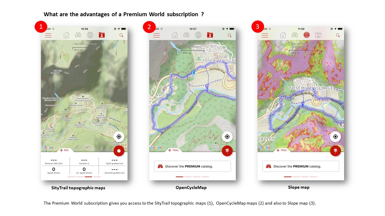
What are the advantages of a Premium World subscription ? 
Zoom in the picture
1) The Premium World subscription gives you access to the SityTrail topographic maps.
2) It also entitles you to the OpenCycleMap maps.
3) It entitles you to the Slope maps.
Wherever you are in the world, SityTrail Premium World guides you on trails and bike paths with reliable altimetry data.
Note : Other functions will be added as an alert when approaching important slopes (useful in case of fog, snowfall or simply during the night).
What are the advantages of a Premium World subscription ? 
1) The Premium World subscription gives you access to the SityTrail topographic maps.
2) It also entitles you to the OpenCycleMap maps.
3) It entitles youto the Slope maps.
Wherever you are in the world, SityTrail Premium World guides you on trails and bike paths with reliable altimetry data.
Note : Other functions will be added as an alert when approaching important slopes (useful in case of fog, snowfall or simply during the night).
Presentation of the differences between Premium mode and Freemium mode
FREEMIUM - 0 €/Year
- Mobile iOS and Android tracking and guiding application for hiking or any outdoor activity.
- Save your trails paths with pictures and technical performances.
- Simple creation of trails and points of interst via the website.
- Organize your personnal data thanks to the lists feature.
- Some advertisements are displayed in mobile application.
PREMIUM - 24.99 €/Year
- Mobile iOS and Android tracking and guiding application for hiking or any outdoor activity.
- Save your trails paths with pictures and technical performances.
- Simple creation of trails and points of interst via the website.
- Organize your personnal data thanks to the lists feature.
- Some advertisements are displayed in mobile application.
+ Advertisements in the mobile application are no longer displayed.
+ Download world topographic maps in offline mode.
+ Access the public catalog of SityTrail members trails.
+ Advanced tracking and guiding features with calculation of the remaining distance and time and vocal instructions at intersections.
+ Create communities.
+ Create trails with advanced editing features.
+ Trail PDF printing with QR Code.
To become Premium member, click there : https://store.geolives.com/GeolivesShop/
Presentation of the differences between the Premium mode and the Freemium mode
Why have prices changed for some subscriptions ? 
All subscriptions are now increased to €24.99 per year per country and also €24.99 per year for the World version for several reasons :
- Each subscription to a country gives as always access to the Topographic maps of the IGN of this country. But it also gives access in addition to the OperStreetMap ( https://www.openstreetmap.org) that you can exploit for this country but also for all your trails abroad and this everywhere in the world.
- For the World version only, following the request of many users, we added, in addition to the SityTrail Topo World maps, marked trails (GR hiking paths, European hiking routes, routes of Santiago de Compostela, ..., cycling networks : Greenway network in France, Ravel in Belgium, European cycling routes, knot points networks in Flanders and Netherlands, ..., ski slopes). We have also added an other map very usefull during a trail. Namely : the Slope Map which is exploitable overlay your topographic maps and this as well on the web as on your smarthphones/tablets in offline mode.
- A point more technical but very important, we have migrated our servers on the Google Cloud infrastructure. This is to greatly improve the stability of our services and to avoid the failures we encountered with our old infrastructure. Of course, this entails significant additional costs.
- Following our survey of more than 1000 users, we brought to the applications many new features and these are finally available via our website : https://www.sitytrail.com . We invite you to discover them !
We are currently considering the possibility of offering combined subscriptions to several countries and/or to World maps for a reduced price in the near future but these subscriptions are not yet defined.
Thank you for your understanding, your trust and your loyalty.
Why have prices changed for some subscriptions ? 
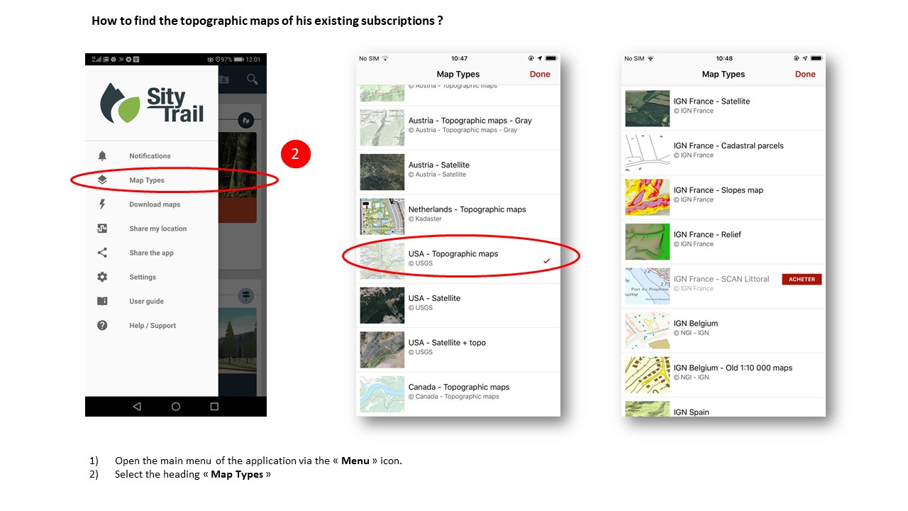
How to find topographic maps of his existing subscriptions ? 
Zoom in the picture
The new version brings together the maps of all the countries within the same application, so it is no longer necessary to download several applications if you hike in different countries.
The maps are accessible according to your subscriptions.
Your active subscriptions subscribed on the classic version of SityTrail remain usable in this new Beta version.
They give you access to country topographic maps, OpenStreetMap (non-topographic) from around the world and Premium features.
For the SityTrail World subscription, it gives you access to the OpenStreetMap, SityTrail Topo World and OpenCycleMap from around the world and Premium features.
If you do not have access to the maps to which you subscribe for or to the Premium features (maps downloading, ...) there are several points to check :
1) Are you connected to your Sity account ? If this is not the case, you only have access to the OpenStreetMap.
2) Are you well connected with the same account as on the old version ?
You have to use the option "Continue with a Sity user or e-mail" on the connection screen and enter the same username as on the old version (or the e-mail address linked to the account you were using on the old version).
If you sign in with Google or Facebook, make sure the e-mail address of your Google or Facebook account is the same as the SityTrail account you were using on the old version. If it is not the case, you can not login by Facebook or Google, you must log via the option "Continue with a Sity user or e-mail".
3) Is your subscription still valid ?
You can check it via "My account" > "My subscriptions" on https://shop.geolives.com
How to find the topographic maps of his existing subscriptions ? 
I can not find my subscriptions. 
The new version brings together the maps of all the countries within the same application, so it is no longer necessary to download several applications if you hike in different countries.
The maps are accessible according to your subscriptions.
Your active subscriptions subscribed on the classic version of SityTrail remain usable in this new Beta version.
They give you access to country topographic maps, OpenStreetMap (non-topographic) from around the world and Premium features.
For the SityTrail World subscription, it gives you access to the OpenStreetMap, SityTrail Topo World and OpenCycleMap from around the world and Premium features.
If you do not have access to the maps to which you subscribe for or to the Premium features (maps downloading, ...) there are several points to check :
1) Are you connected to your Sity account ? If this is not the case, you only have access to the OpenStreetMap.
2) Are you well connected with the same account as on the old version ?
You have to use the option "Continue with a Sity user or e-mail" on the connection screen and enter the same username as on the old version (or the e-mail address linked to the account you were using on the old version).
If you sign in with Google or Facebook, make sure the e-mail address of your Google or Facebook account is the same as the SityTrail account you were using on the old version. If it is not the case, you can not login by Facebook or Google, you must log via the option "Continue with a Sity user or e-mail".
3) Is your subscription still valid ?
You can check it via "My account" > "My subscriptions" on https://shop.geolives.com
I can not find my subscriptions 
I have to renew my subscriptions. Why have prices changed for some subscriptions ?
All subscriptions are now increased to €24.99 per year per country and also €24.99 per year for the World version for several reasons :
- Each subscription to a country gives as always access to the Topographic maps of the IGN of this country. But it also gives access in addition to the OperStreetMap ( https://www.openstreetmap.org) that you can exploit for this country but also for all your trails abroad and this everywhere in the world.
- For the World version only, following the request of many users, we added, in addition to the SityTrail Topo World maps, marked trails (GR hiking paths, European hiking routes, routes of Santiago de Compostela, ..., cycling networks : Greenway network in France, Ravel in Belgium, European cycling routes, knot points networks in Flanders and Netherlands, ..., ski slopes). We have also added an other map very usefull during a trail. Namely : the Slope Map which is exploitable overlay your topographic maps and this as well on the web as on your smarthphones/tablets in offline mode.
- A point more technical but very important, we have migrated our servers on the Google Cloud infrastructure. This is to greatly improve the stability of our services and to avoid the failures we encountered with our old infrastructure. Of course, this entails significant additional costs.
- Following our survey of more than 1000 users, we brought to the applications many new features and these are finally available via our website : https://www.sitytrail.com . We invite you to discover them !
We are currently considering the possibility of offering combined subscriptions to several countries and/or to World maps for a reduced price in the near future but these subscriptions are not yet defined.
Thank you for your understanding, your trust and your loyalty.
I have to renew my subscriptions. Why have prices changed for some subscriptions ? 
I can not find my trails from the old platform in the new one. 
Your trails created on the classic version of SityTrail have been automatically imported to your account on the new version at a given moment (the last import dates from early January 2019).
However, the trails created since this date or modified since their import have not been imported/updated yet.
You muste import / update them manually. You can do it via the " Dashboard" : https://www.sitytrail.com/fr/users/me/dashboard
At the very bottom of the screen, you will find "SityTrail Import". Click on it, then follow the instructions.
Warning : If you want the selected trails to be updated if they already exist in the Beta version, check the box "Replace existing trails" in the 2nd step of the import assistance.
You may also need to remove from the new version trails that you would have deleted in the old version in meantime. Thanks you for your understanding.
I can not find my trails from the old plateform in the new one 
What features are planned for future updates ? 
Generally 
- Set up the possibility to purchase subscriptions directly from the Beta version.
Currently, purchases of our products are still made via our online store https://store.geolives.com and these old subscriptions are also valid on the Beta version.
- To be able to coordinates latitude /longitude and UTM in cartographic consultation and all the places presenting coordinates on the site and the mobile application.
- To be able to display the UTM grid on the map.
Web Applications 
- To be able to simplify a plot (remove the unnecessary points), entirely or by zones.
- To propose to print several trails on the same map.
- To allow to change his username / public profile name.
- The possibility to share trails only with friends / manage friends list.
- The possibility of dialogue between the users of the applications (concerning a trail, ...) via an internal messaging.
Mobiles applications (as well on Android as on iOS)
- Creation of Points of interest (with name and description) and landmarcks (at a location on the map, at the GPS location, by coordinates, ...)
- Import / export og the GPX files directly from the mobile application without going through theWebsite (as well as opening GPX files from the mobile browser, or attached to an e-mail, ...)
- Possibility to trace/edit trails directly from the mobile application.
- To stop the counter automatically (optionnaly) in case of pause.
- To share the link of a trail or a point of interest, in particular by e-mail.
Android Application (specifically) 
iOS Application (specifically) 
- Send comments on the trails
Features currently not planned (for technic reasons or other reasons) 
Web applications
- Possibility to print on a precise scale (1/25 000 for example) : printing at an intermediate zoom level between two zoom levels accessible using the mouse wheel is unfortunately technically not possible because the levels of zoom offered by different map providers (OpenStreetMap, IGN, ...) are limited to these zoom levels and the printing of maps between these zoom levels would greatly degrade the quality of the print.
Mobile Application (Android and iOS) 
Android Application 
iOs Application 
What features are planned for future updates ? 
I can not find my landmarcks created on the old mobile applications 
For Android 
The landmarcks will automatically be imported to the new application as points of interest when the final version of the application is released, which will also allow you to create new ones. Thanks for your patience.
For iOS 
When switching to the latest Beta version, which replace the SityTrail France application update via TestFlight, previously created landmarcks on SityTrail France are converted to points of interest on the new version as soon as you have logged in you account and you launch the applicaton with the reliable Internet connection (Wifi, 4G or 3G).
You can find these points of interest corresponding to your landmarcks in a specific list named "Landmarcks" + the date of the import.
It is currently not yet possible to view them on the map in the mobile application (this will be the subject of a very next update) or to create new ones (this will be possible with the publication of the final version of the application).
However, for constraints related to the validation of applications by Apple, the landmarcks created with the older applications other than SityTrail France (SityTrail Belgium, SityTrail World, ...) unfortunately can not be imported into the new version of the application, you will need to recreate them manually, please excuse us.
I can not find my landmarcks created on the old mobile applications
The recording of my trail is not done in the background or screen off 
Check that you have not activated a power saving mode in your device's battery settings or another setting that would cause the GPS to stop when the screen is off.
- On Sony devices in particular, the activation of the "Stamina mode" causes this problem.
- On Samsung devices too, some power saving modes causes the GPS to stop when the screen is off.
- On Huawei/Honor devices, a particular procedure must be applied. Please read the specific section below.
The application does not work in the background on Huawei and Honor devices 
On Huawei and Honor devices, a limitation of applications running in the very restrictive background is applied by default.
So that our application can work in the background (to record your track or to follow a trail, ...), a particular configuration is necessary.
Here's the procedure to follow :
1) First, check the battery settings of your device that no power saving mode is enabled.
2) Next, you must allow the application to run in the background. The procedure depend on the version of Android installed on your device (you can check this via the "About" section of the device settings).
On Android 6 : the application must be added to the list of protected applications. To do this, go to the "Protected Applications" section of your device's battery settings and check the box corresponding to our application.
On Android 7 : The application must be removed from the list of applications that close the screen lock. To do this, go to the "Close the application after screen lock" section of your device's battery settings and uncheck the box correponsding to our application (if it is checked).
On Android 8 : In the "Launch" section of your device's battery settinfs, uncheck the automatic management of the application and then check the 3 boxes (automatic launch, secondary launch and background execution).
The recording of my trails is not done in the background or screen off 
The application is no longer compatible with my device 
Unfortunately, for some technical reasons, this new version is only compatible with the device running Android 5.0 and higher and for the iPhones / iPads running iOS 11 and higher (which corresponds to the iPhone 5S or the iPas Air minimum).
We apologize.
Unfortunately, we can no longer support versions of Android and iOS older than 5 years, please excuse us.
Feel free to check in your device's settings, or with its manufacturer, that an update is not possible to a newer version of iOS or Android.
Thanks you for your understanding.
The application is no longer compatible with my device 
How to create a SityTrail account ?
Creating a SityTrail account is a simple, easy and fast operation.
First, you need to go on the SityTrail homepage.
Then you will have to proceed to the following steps:
1) Click either at the top right of the "login" tab or at the bottom of the "register for free" tab.
2) Then click on "Create a SityTrail account" .
3) Finally, you just have to fill in the fields proposed by the software: your email, your password, your username, ...
Congratulations, you are now a SityTrail customer. Welcome.
How to change my email address?
1) Click on the "settings",
2) Select the tab "change my email ".
3) Fill in the proposed fields.
How to change my avatar?
Two options are available to you:
1) You can click on the current avatar and select a file in your computer that you wish to use as a new avatar (photo or image).
Then follow the instructions on your computer.
2) Once logged in, go to the "settings" and click on the "change avatar" tab.
Then choose a file in your computer that you want to use as an avatar (picture or image) and follow the instructions on your computer.
How to change my password?
1) Once connected, go to the "settings".
2) Then select the "Account Security" tab.
3) Finally, complete the fields provided and follow the instructions on your computer.
How to connect to my SityTrail account?
Three possibilities are available to you:
FACEBOOK CONNECTION:
1) Click on "continue with facebook".
2) Follow the different steps that will be proposed to you.
GOOGLE CONNECTION:
1) Click on "continue with Google".
2) Select the google account you want to use.
3) Follow the instructions by clicking on the "link account" tab.
After that, your google account will be connected to your Sitytrail account.
MAIL ADDRESS CONNECTION:
1) Click on "continue with an email address".
2) Fill in the proposed fields.
3) Click on "sign in" to get into your Sitytrail account.
How to recover my forgotten password?
If you have lost your password, do not panic, nothing more than to recover it.
For it,
1) Click on the "connection" tab.
2) Select the "continue with an email address" tab.
3) Click on the forgotten password tab.
4) Encode your email address.
5) Follow the instructions on your computer.
How to import my data from the old platform ? 
Article in preparation.
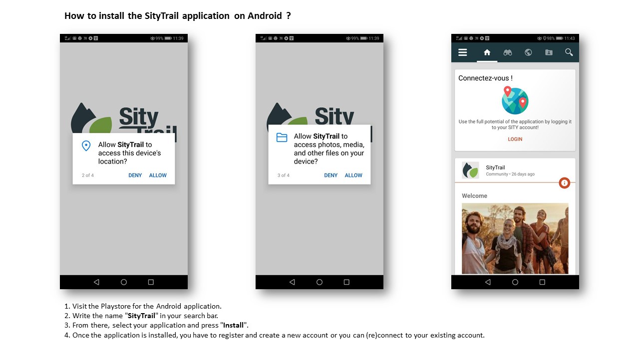
How to install the SityTtrail application on Android ?
Zoom in the picture
1) Visit the Playstore for the Android application.
2) Write the name "SityTrail" in your search bar.
3) From there, select your application and press "Install".
4) Once the application is installed, you have to register and create a new account or you can (re)connect to your existing account.
Welcome.
Important note :Why the Android application require access to my contacts ?
It is a bug at Google. It will be corrected soon.
However, Geolives certifies that the SityTrail application does not use the data of your contacts.
More Ggoogle information on this link, in English :
https://developer.android.com/about/versions/oreo/android-8.0-changes#rmp
How to install the SityTtrail application on Android ?
1) Visit the Playstore for the Android application.
2) Write the name "SityTrail" in your search bar.
3) From there, select your application and press "Install".
4) Once the application is installed, you have to register and create a new account or you can (re)connect to your existing account.
Welcome.
Important note :Why the Android application require access to my contacts ?
It is a bug at Google. It will be corrected soon.
However, Geolives certifies that the SityTrail application does not use the data of your contacts.
More Ggoogle information on this link, in English :
https://developer.android.com/about/versions/oreo/android-8.0-changes#rmp
How to access his trails stored on the mobile ? 
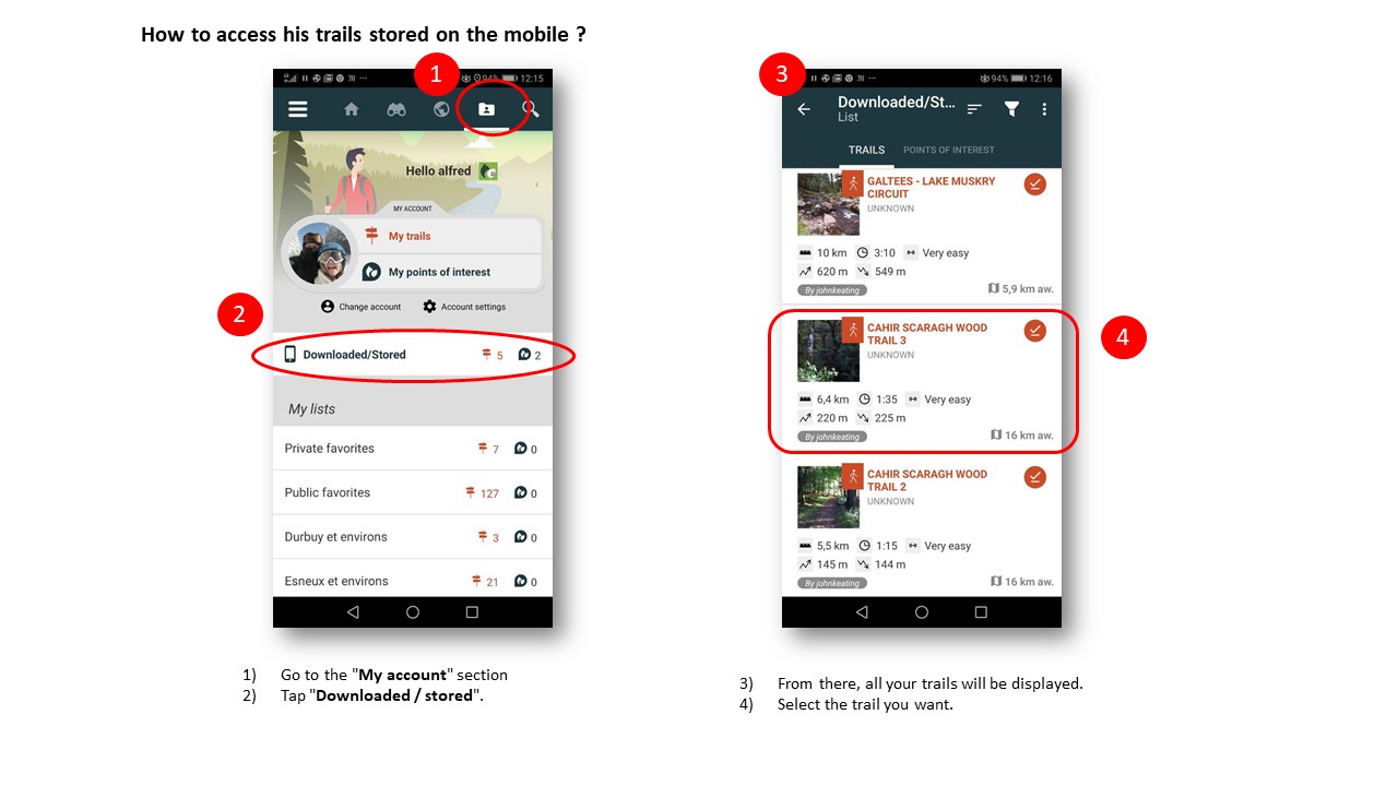
1) Go to the "My account" section
2) Tap "Downloaded / stored".
3) From there, all your trails will be displayed.
How to access his trails stored on the mobile ?
1) Go to the "My account" section
2) Tap "Downloaded / stored".
3) From there, all your trails will be displayed.
How to access his trails from his server account ? 
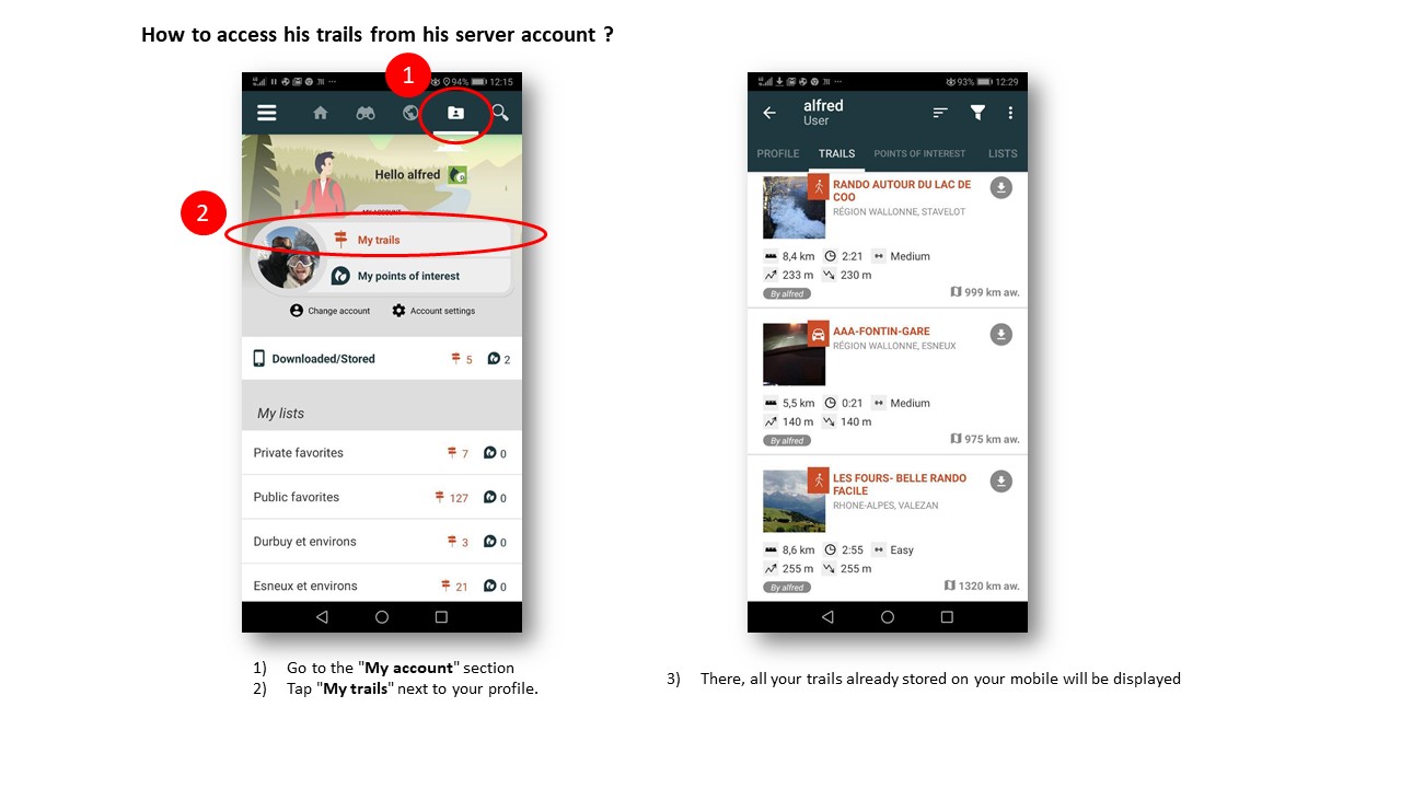
Zoom in the picture
1) Go to the "My account" section
2) Tap "My trails" next to your profile.
3) There, all your trails already stored on your mobile will be displayed.
How to access his trails from his server account ? 
1) Go to the "My account" section
2) Tap "My trails" next to your profile.
3) There, all your trails already stored on your mobile will be displayed.
How to (re)connect to his SityTrail account ? 
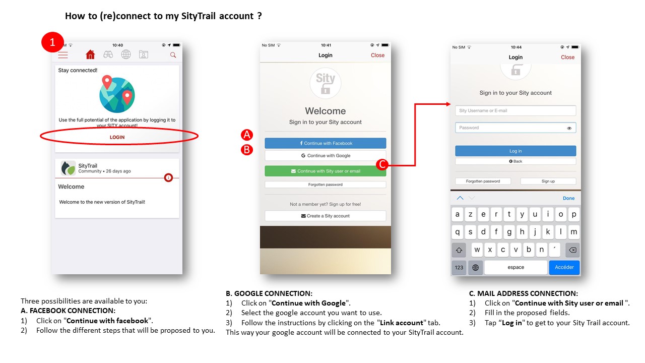
Zoom in the picture
Three possibilities are available to you:
A. FACEBOOK CONNECTION:
1) Click on "Continue with facebook".
2) Follow the different steps that will be proposed to you.
B. GOOGLE CONNECTION:
1) Click on "Continue with Google".
2) Select the google account you want to use.
3) Follow the instructions by clicking on the "Link account" tab.
This way your google account will be connected to your SityTrail account.
C. MAIL ADDRESS CONNECTION:
1) Click on "Continue with Sity user or email".
2) Fill in the proposed fields.
3) Tap "Log in" to get to your Sity Trail account.
How to connect to my SityTrail account?
Three possibilities are available to you:
A. FACEBOOK CONNECTION:
1) Click on "Continue with facebook".
2) Follow the different steps that will be proposed to you.
B. GOOGLE CONNECTION:
1) Click on "Continue with Google".
2) Select the google account you want to use.
3) Follow the instructions by clicking on the "Link account" tab.
This way your google account will be connected to your SityTrail account.
C. MAIL ADDRESS CONNECTION:
1) Click on "Continue with an email address".
2) Fill in the proposed fields.
3) Tap "Sign in" to get to your Sity Trail account.
Connection option for downloading maps 
Connection option for downloading maps 
How to create a trail via the app?
You cannot edit a trail via the app. This is only feasible via the website.
However, a trail can be registered via the application (How to register a trail?), and it will be immediately transferred to your account.
How to change the display of tracks ? 
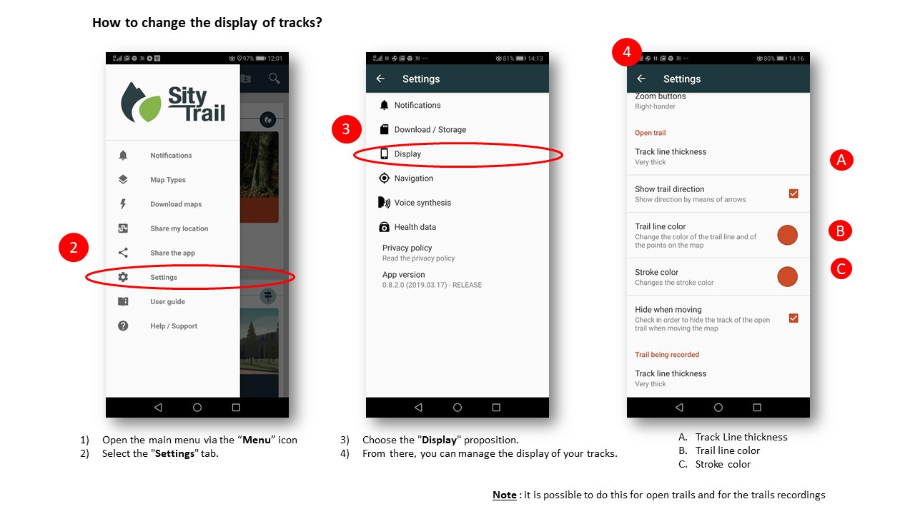
Zoom in the picture
1) Open the main menu via this icon: 
2) Select the "Settings" tab.
3) Choose the "Display" proposition.
From there, you can manage the display of your tracks.
Note : it is possible to do this for open trails and for the trails recordings
How to change the display of tracks?
1) Open the main menu via this icon:
2) Select the "Settings" tab.
3) Choose the "Display" proposition.
From there, you can manage the display of your tracks.
Note : it is possible to do this for open trails and for the trails recordings.
How to change the display of the GPS slider ? 
How to change the display of the GPS slider ? 
How to know if a map has been downloaded?
1) Tap the icon at the top left-hand corner of your screen
2) Select the "download maps" tab.
Note: All maps in this topic are your downloaded map areas for which you have offline access.
Health data 
Health Data 
How to install the SityTrail application on iOS ? 
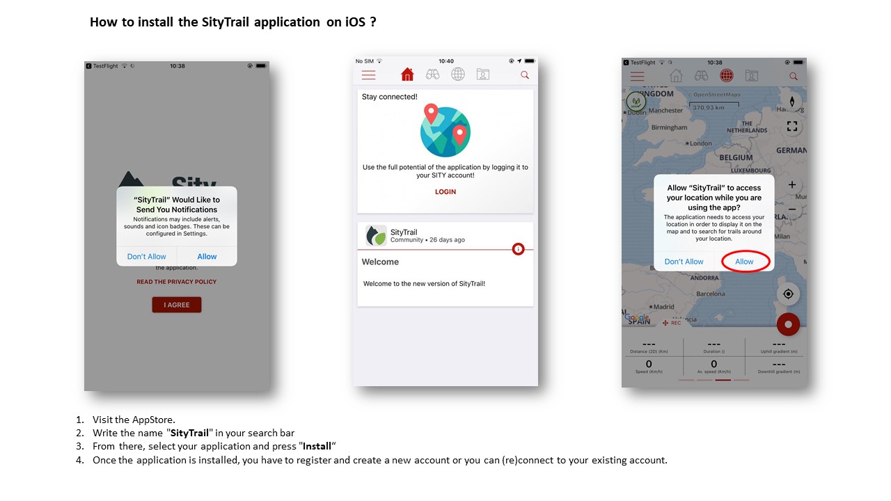
Zoom in the picture
1) Visit the AppStore.
2) Write the name "SityTrail" in your search bar
3) From there, select your application and press "Install“
4) Once the application is installed, you have to register and create a new account or you can (re)connect to your existing account.
Note : When the application is first launched, please choose "Always allow" to keep the GPS always active even when the screen is off.
Welcome.
How to install the SityTrail application on iOS ? 
1) Visit the AppStore.
2) Write the name "SityTrail" in your search bar.
3) From there, select your application and press "Install".
4) Once the application is installed, you have to register and create a new account or you can (re)connect to your existing account.
Note : When the application is first launched, please choose "Always allow" to keep the GPS always active even when the screen is off.
Welcome.
How to manage his notifications ? 
1) Open the main menu via this icon:
2) Select the "Settings" tab.
3) Once in this section, choose the first proposal "Notifications" 
4) From there, you can manage your notifications.
How to manage my notifications?
1) Open the main menu via this icon:
2) Select the "Settings" tab.
3) Once in this section, choose the first proposal "Notifications"
4) From there, you can manage your notifications.
How to see his notifications ? 
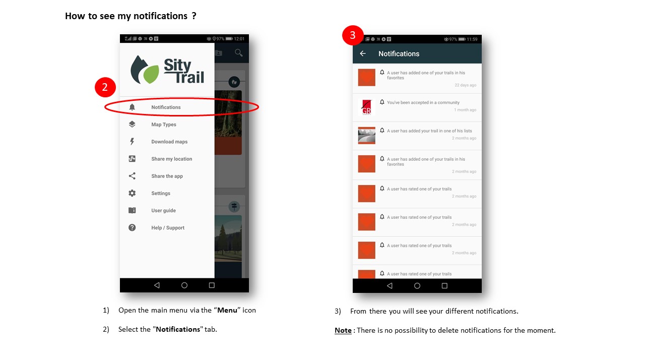
Zoom in the picture
1) Open the main menu via this icon:
2) Select the "Notifications" tab.
3) From there you will see your different notifications.
Note : There is no possibility to delete notifications for the moment.
How to see my notifications?
1) Open the main menu via this icon:
2) Select the "Notifications" tab.
3) From there you will see your different notifications.
Note : There is no possibility to delete notifications for the moment.
Map screen display option 
Map screen display option 
How to manage your profile from the mobile application ? 
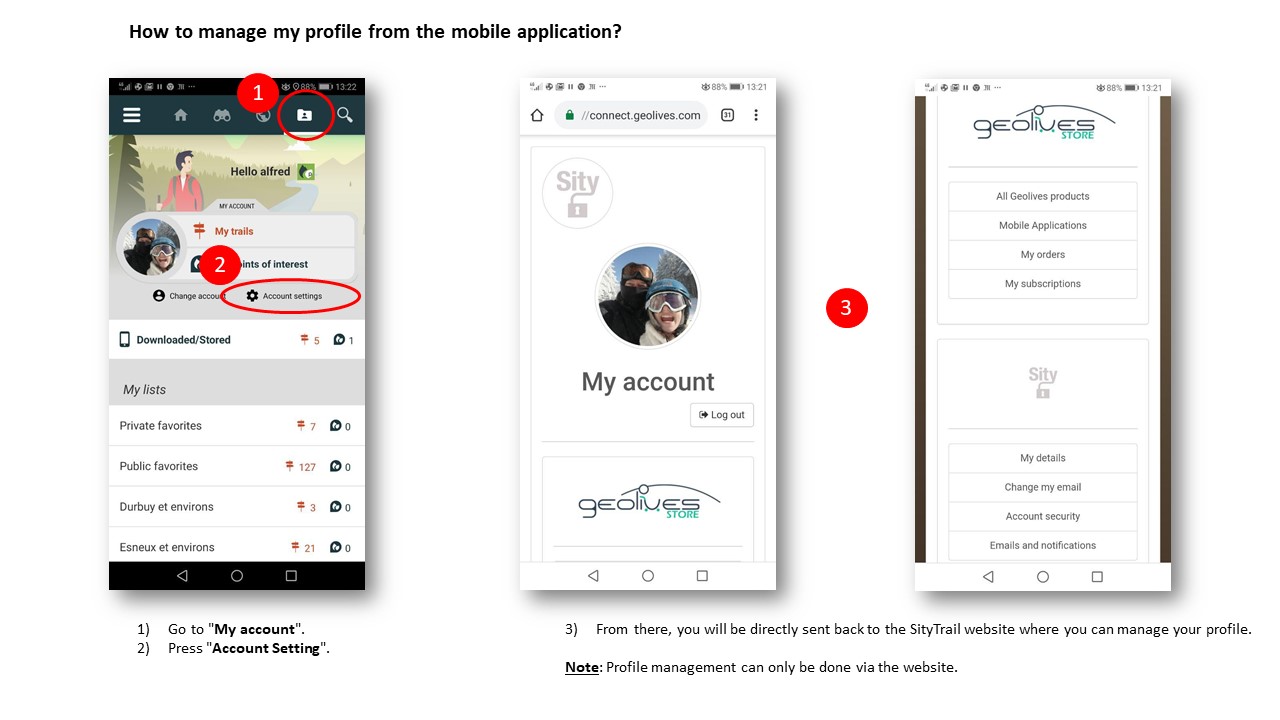
Zoom in the picture
1) Go to "My account"
2) Press "Account Setting".
3) From there, you will be directly sent back to the SityTrail website where you can manage your profile.
Note: Profile management can only be done via the website.
How to manage my profile from the mobile application?
1) Go to "My account".
2) Press "Account Setting".
3) From there, you will be directly sent back to the SityTrail website where you can manage your profile.
Note: Profile management can only be done via the website.
How to register on SityTrail ? 
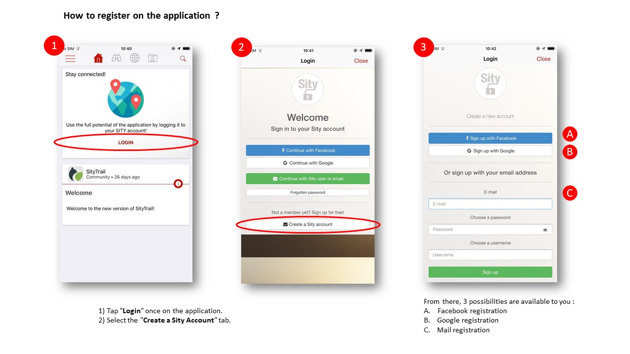
Zoom in the picture
1) Tap "Login" once on the application.
2) Select the "Create a Sity Account" tab.
From there, 3 possibilites are available to you :
A. FACEBOOK REGISTRATION
1) Click on the "Facebook registration" tab.
2) Follow the different staps that will be proposed to you.
B. GOOGLE REGISTRATION
1) Click on the "Google Registration" tab.
2) Choose your Google account.
3) Follow the instructions by clicking on the "Link Account" tab.
This way, your Google account will be linked to your SityTrail account.
C. MAIL REGISTRATION
1) Fill in the proposed fields (email, password and username).
2) Press on "Registration" to get to your new SityTrail account.
How to register on the application?
1) Tap "Login" once on the application.
2) Select the "Create a Sity Account" tab.
From there, 3 possibilites are available to you :
A. FACEBOOK REGISTRATION
1) Click on the "Facebook registration" tab.
2) Follow the different staps that will be proposed to you.
B. GOOGLE REGISTRATION
1) Click on the "Google Registration" tab.
2) Choose your Google account.
3) Follow the instructions by clicking on the "Link Account" tab.
This way, your Google account will be linked to your SityTrail account.
C. MAIL REGISTRATION
1) Fill in the proposed fields (email, password and username).
2) Press on "Registration" to get to your new SityTrail account.
How to share the application ? 
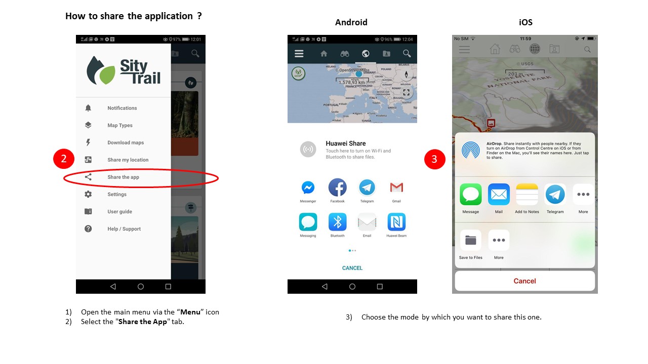
Zoom in the picture
1) Open the main menu via this icon:
2) Select the "Share the app" tab.
3) Choose the mode by which you want to share this one
How to share the application?
1) Open the main menu via this icon:
2) Select the "Share Application" tab.
3) Choose the mode by which you want to share this one.
How to share his location/SOS ? 
1) Open the main menu via this icon:
2) Select the "Share position / SOS" tab.
3) Next, tap the icon  at the bottom right-hand corner of your screen.
4) Select the mode by which you want to share your location.
Important note for a SOS message :
Whether in the mountain or in an area that does not have good internet coverage (Data Network), it is better to send your GPS position by "Message" that is to say by SMS.
Indeed, SMS network coverage is much safer and generally works around the world.
How to share my location via the app?
1) Open the main menu via this icon:
2) Select the "Share position / SOS" tab.
3) Next, tap the icon at the bottom right-hand corner of your screen.
4) Select the mode by which you want to share your location.
Important note for a SOS message :
Whether in the mountain or in an area that does not have good internet coverage (Data Network), it is better to send your GPS position by "Message" that is to say by SMS.
Indeed, SMS network coverage is much safer and generally works around the world.
How to switch accounts or sign out of the SityTrail application ?
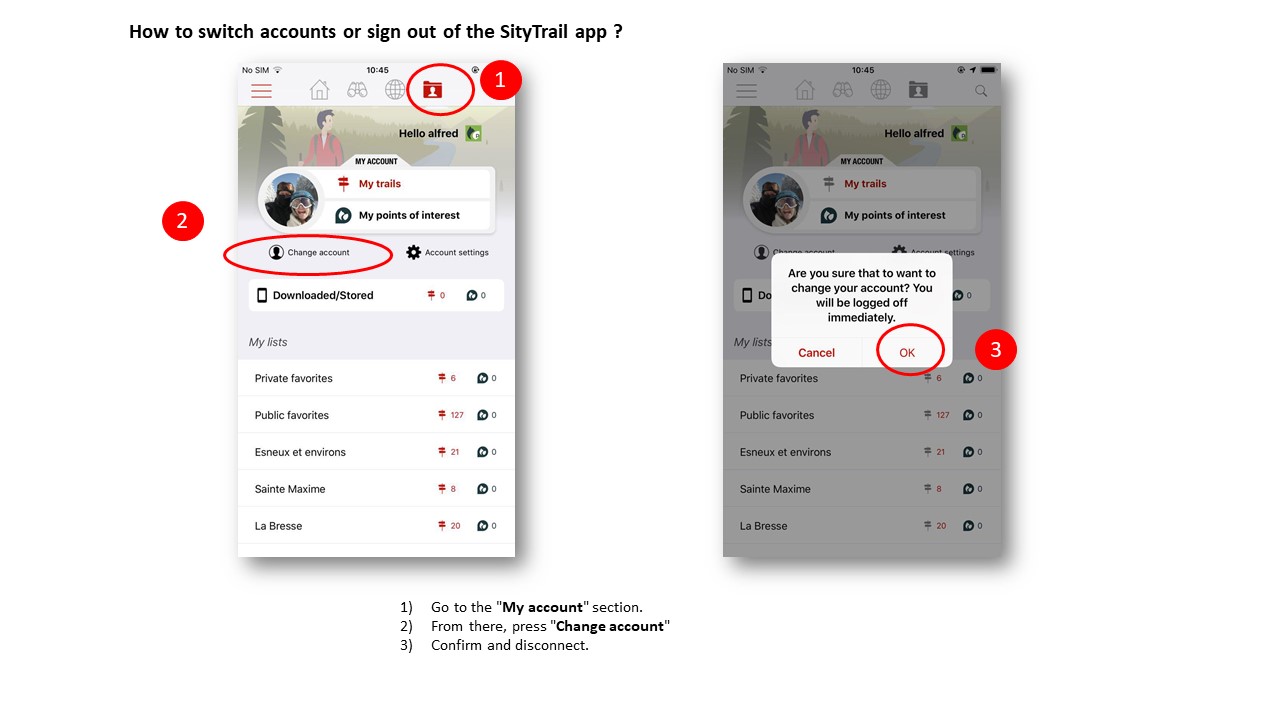
Zoom in the picture
1) Go to the "My account" section
2) From there, press "Change account"
3) Confirm and disconnect.
How to switch accounts or sign out of the Sitytrail app?
1) Go to the "My account" section.
2) From there, press "Change account"
3) Confirm and disconnect.
How to know the version number of the application ? 
How to know the version number of the application ? 
Vocal synthesis 
Vocal Synthesis 
What is a list?
A list allows you to group trails under a theme, a place, ...
The lists are therefore folders to classify your trails.
Here are some examples:
- Create a list of trails for your next holidays.
- Create a list of trails for a CLUB or a list to share with other members.
- Create a list for a particular event.
You can create as many lists as you want.
How to add a trail to a list?
1) Once connected, go to "discover".
2) Search for a trail.
3) Select the trail you want to add to your lists.
4) The details of the trail are displayed and you can click on the button "add to my lists" .
5) Then choose the list to which you want to add the trail.
How to create a list?
1) Sign in to your Sitytrail account.
2) Go to the "dashboard".
3) Then click on "manage my lists". From there, all your lists will be presented to you.
4) Create a new list by clicking on the "+ create a list" tab.
5) You will then be asked to enter a name for your new list.
If you want to delete a list, click on this link : How to delete a list?
Note: The lists you create on the website are also present on your mobile application.
How to delete a list?
1) Go to the "dashboard".
2) Then, click on "manage my lists".
3) From there select the list you want to delete and click on the trash icon  on the right of the list.
4) After all these steps, make sure you delete your list by clicking on the "yes" tab.
Note: You cannot delete the default lists such as "Public Favorites" or "Private Favorites".
How to manage my lists?
1) Sign in to your Sitytrail account.
2) Go to the "dashboard".
3) Then click on "manage my lists".
From there, all your lists will be presented to you and you can modify them as you want.
How to remove a trail to a list?
1) Once connected, go to the "dashboard".
2) Select the tab "my lists".
3) Click on the list where the trail you want to delete is located.
4) Once in the list, click on the "remove" icon  which is on the right of the trail you want to delete.
How to change the visibility of my lists?
1) Go to the "dashboard".
2) Then, click on "manage my lists".
3) From there, select the list you want to make public or private.
4) Then enable or disable "public list".
Note: the strikethrough eye means that the list is private. If there is nothing, the list remains public.
Why are we not able to delete some lists?
Each user has two lists created automatically during the first use.
These lists (private favorites and public favorites) are identical for all users and cannot be modified and / or deleted.
You are of course free to choose the contents of these lists.
How to delete notifications?
Article in preparation.
How to manage notifications?
1) Go to the "settings".
2) Select the "email and notifications" tab.
3) From there, tick or untick the box that interests you.
4) Make sure to click on the "validate" tab at the bottom right of your screen so that your action is effective.
How to record a trail ? 
1) Go to the "Map" screen. 
2) Click on your geolocation by pressing the GPS icon 
3) In the area at the bottom of your screen, move your finger on the "REC" tab (Trail record).
4) Once you're ready to start, tap the "Red button with white point".
5) You have gone to record your trail and take beautiful pictures !
6) You can access all the values on the "Bike/Ride Meter" screen by simply pulling the "REC" box up.
Important notes:
In the bottom of your screen, it is possible to switch from one information area to another by scrolling your finger on the bottom of the screen (from right to left).
Note that there are 4 information area : TRAIL (hiking trail), GPS (gps values), REC (trail record), ALT (altimetric profile).
Trick : when you are in the TRAIL hike tracking screen, you can immediately go to the 4th ALT information area bu sliding the screen with your finger, not to the left, but to the right.
How to record a trail?
1) Go to the "Map" screen.
2) Click on your geolocation by pressing the GPS icon.
3) In the area at the bottom of your screen, move your finger on the "REC" tab (Trail record).
4) Once you're ready to start, tap the "Red button with white point".
5) You have gone to record your trail and take beautiful pictures !
6) You can access all the values on the "Bike/Ride Meter" screen by simply pulling the "REC" box up.
Important notes:
In the bottom of your screen, it is possible to switch from one information area to another by scrolling your finger on the bottom of the screen (from right to left).
Note that there are 4 information area : TRAIL (hiking trail), GPS (gps values), REC (trail record), ALT (altimetric profile).
Trick : when you are in the TRAIL hike tracking screen, you can immediately go to the 4th ALT information area bu sliding the screen with your finger, not to the left, but to the right.
How to access the recorder?
1) Go to the "map" section of your application
2) Go to the information area that you can move from left to right to access the different items with a swipe.
3) Once under the heading "REC" (trail recorder), press the red icon "recording" ** to start a recording.
Note: To access the various data of the recorder throughout your trail, drag it up.
How to optimize your battery?
Article in preparation.
How to use the GPS when recording the trail?
Article in preparation.
How to take photos during a trail record ? 
1) Once the recording has started,
2) Go to the "REC" section,
3) Then press the "Camera" icon. 
Note: Each time you take pictures, a pictogram will appear on your track.
If you want to remove the photo icons from your track during the recording, tap the black "Point of interest" icon (A) at the top left of your screen.
If you want to make them appear again, repeat the operation.
How to add photos when registering a hike?
1) Once the recording has started,
2) Go to the "REC" section,
3) Then press the "Camera" icon.
Note: Each time you take pictures, a pictogram will appear on your track.
If you want to remove the photo icons from your track during the recording, tap the black "Point of interest" icon (A) at the top left of your screen.
If you want to make them appear again, repeat the operation.
How to end a trail record ? 
1) Press the green "Stop" icon at the bottom right-hand corner of your screen.
2) Be sure to press the "Save" tab.
3) From there, name the trail, decide on the visibility of it, describe it, define an outdoor activity and the difficulty of it.
4) Finally, press "Validate" and your trail is saved!
How to stop a trail’s recording?
1) Press the green "Stop" icon at the bottom right-hand corner of your screen.
2) Be sure to press the "Save" tab.
3) From there, name the trail, decide on the visibility of it, describe it, define an outdoor activity and the difficulty of it.
4) Finally, press "Validate" and your trail is saved!
How to add photos to a trail?
Article in preparation.
How to delete photos from a trail?
Article in preparation.
Is there a limited number of photos per trail?
Article in preparation.
What is the photo resolution proposed by Sitytrail?
Article in preparation.
Are my photos visible by other Sity members?
The photos of your trails are visible by other members only if you choose to publish your trail in a public mode.
If it is published in Private mode, the photos are visible to no one else than you.
If you want to change the visibility of your trail, click on the following link : How to make my trail public or private?
Why become a Premium Member?
With SityTrail Premium, you can download our world coverage topographic map for offline use.
You can also enjoy the trails catalog from the community
FREE- 0 €/Year
- Mobile iOS and Android tracking and guiding app for hiking or any outdoor activity.
- Save your trails paths with pictures and technical performances.
- Simple trails and places creation.
- Organize you data thanks to the lists feature.
PREMIUM- 19.99 €/Year
- Mobile iOS and Android tracking and guiding app for hiking or any outdoor activity.
- Save your trails paths with pictures and technical performances.
- Simple trails and places creation.
- Organize you data thanks to the lists feature.
- Download world topographic maps for offline use.
- Access the public trails catalog.
- Advanced tracking and guiding features with calculation of the remaining distance and time and vocal instructions at intersections.
- Create hikers communities.
- Advanced trails creation.
- Trail PDF printing with QR-CODES.
How to end my Premium subscription?
Article in preparation.
How to become a Premium member?
To become a premium member, you can first have a free trial period for 1 week to test all the advanced features offered by this subscription. Then you will be offered to continue as a Sity Trail Premium member for the price of 19.99 / year.
You can also take the Premium Membership without going through the free trial period.
To see the advanced options you have access to by being Premium member, click on the link Why become a Premium member?
How to renew my Premium subscription?
Article in preparation.
How to exploit the compass mode to find his way ? 
How to exploit the compass mode to find his way ? 
How to exploit the different modes of the GPS button ? 
How to exploit the different modes of the GPS button ? 
How to navigate the map (2D/3D) ? 
How to navigate the map (2D/3D) ? 
Privacy Policy
This Privacy Policy governs the manner in which Geolives Belgium S.P.R.L. collects, uses, maintains and discloses information collected from users (each, a "User") of the SityTrail website ("Site"). This privacy policy applies to the Site and all products and services offered by Geolives Belgium S.P.R.L.
Personal identification information
We may collect personal identification information from Users in a variety of ways, including, but not limited to, when Users visit our site, register on the site, place an order, subscribe to the newsletter, and in connection with other activities, services, features or resources we make available on our Site. Users may be asked for, as appropriate, name, email address, mailing address. We will collect personal identification information from Users only if they voluntarily submit such information to us. Users can always refuse to supply personally identification information, except that it may prevent them from engaging in certain Site related activities.
Non-personal identification information
We may collect non-personal identification information about Users whenever they interact with our Site. Non-personal identification information may include the browser name, the type of computer and technical information about Users means of connection to our Site, such as the operating system and the Internet service providers utilized and other similar information.
Web browser cookies
Our Site may use "cookies" to enhance User experience. User's web browser places cookies on their hard drive for record-keeping purposes and sometimes to track information about them. User may choose to set their web browser to refuse cookies, or to alert you when cookies are being sent. If they do so, note that some parts of the Site may not function properly.
How we use collected information
Geolives Belgium S.P.R.L. may collect and use Users personal information for the following purposes:
- To improve customer service
Information you provide helps us respond to your customer service requests and support needs more efficiently.
- To personalize user experience
We may use information in the aggregate to understand how our Users as a group use the services and resources provided on our Site.
- To improve our Site
We may use feedback you provide to improve our products and services.
- To run a promotion, contest, survey or other Site feature
To send Users information they agreed to receive about topics we think will be of interest to them.
- To send periodic emails
We may use the email address to send them information and updates pertaining to their order. If User decides to opt-in to our mailing list, they will receive emails that may include company news, updates, related product or service information, etc. If at any time the User would like to unsubscribe from receiving future emails, we include detailed unsubscribe instructions at the bottom of each email.
How we protect your information
We adopt appropriate data collection, storage and processing practices and security measures to protect against unauthorized access, alteration, disclosure or destruction of your personal information, username, password, transaction information and data stored on our Site.
Sensitive and private data exchange between the Site and its Users happens over a SSL secured communication channel and is encrypted and protected with digital signatures.
Sharing your personal information
We do not sell, trade, or rent Users personal identification information to others. We may share generic aggregated demographic information not linked to any personal identification information regarding visitors and users with our business partners, trusted affiliates and advertisers for the purposes outlined above.
Third party websites
Users may find advertising or other content on our Site that link to the sites and services of our partners, suppliers, advertisers, sponsors, licensors and other third parties. We do not control the content or links that appear on these sites and are not responsible for the practices employed by websites linked to or from our Site. In addition, these sites or services, including their content and links, may be constantly changing. These sites and services may have their own privacy policies and customer service policies. Browsing and interaction on any other website, including websites which have a link to our Site, is subject to that website's own terms and policies.
Advertising
Ads appearing on our site may be delivered to Users by advertising partners, who may set cookies. These cookies allow the ad server to recognize your computer each time they send you an online advertisement to compile non personal identification information about you or others who use your computer. This information allows ad networks to, among other things, deliver targeted advertisements that they believe will be of most interest to you. This privacy policy does not cover the use of cookies by any advertisers.
Google Adsense
Some of the ads may be served by Google. Google's use of the DART cookie enables it to serve ads to Users based on their visit to our Site and other sites on the Internet. DART uses "non personally identifiable information" and does NOT track personal information about you, such as your name, email address, physical address, etc. You may opt out of the use of the DART cookie by visiting the Google ad and content network privacy policy athttps://www.google.com/privacy_ads.html
Requesting removal of your account
You can request the removal of your account and the deletion of all your data via our support web form on https://help.geolives.com or by e-mail : help@geolives.com
Changes to this privacy policy
Geolives Belgium S.P.R.L. has the discretion to update this privacy policy at any time. When we do, we will revise the updated date at the bottom of this page. We encourage Users to frequently check this page for any changes to stay informed about how we are helping to protect the personal information we collect. You acknowledge and agree that it is your responsibility to review this privacy policy periodically and become aware of modifications.
Your acceptance of these terms
By using this Site, you signify your acceptance of this policy. If you do not agree to this policy, please do not use our Site. Your continued use of the Site following the posting of changes to this policy will be deemed your acceptance of those changes.
Contacting us
If you have any questions about this Privacy Policy, the practices of this site, or your dealings with this site, please contact us at:
contact@geolives.com
This document was last updated on September 7, 2021
Versions history
Privacy policy - Version of June 1, 2018
Privacy policy - Version of June 1, 2018
This Privacy Policy governs the manner in which Geolives Belgium S.P.R.L. collects, uses, maintains and discloses information collected from users (each, a "User") of the SityTrail website ("Site"). This privacy policy applies to the Site and all products and services offered by Geolives Belgium S.P.R.L.
Personal identification information
We may collect personal identification information from Users in a variety of ways, including, but not limited to, when Users visit our site, register on the site, place an order, subscribe to the newsletter, and in connection with other activities, services, features or resources we make available on our Site. Users may be asked for, as appropriate, name, email address, mailing address. We will collect personal identification information from Users only if they voluntarily submit such information to us. Users can always refuse to supply personally identification information, except that it may prevent them from engaging in certain Site related activities.
Non-personal identification information
We may collect non-personal identification information about Users whenever they interact with our Site. Non-personal identification information may include the browser name, the type of computer and technical information about Users means of connection to our Site, such as the operating system and the Internet service providers utilized and other similar information.
Web browser cookies
Our Site may use "cookies" to enhance User experience. User's web browser places cookies on their hard drive for record-keeping purposes and sometimes to track information about them. User may choose to set their web browser to refuse cookies, or to alert you when cookies are being sent. If they do so, note that some parts of the Site may not function properly.
How we use collected information
Geolives Belgium S.P.R.L. may collect and use Users personal information for the following purposes:
- To improve customer service
Information you provide helps us respond to your customer service requests and support needs more efficiently.
- To personalize user experience
We may use information in the aggregate to understand how our Users as a group use the services and resources provided on our Site.
- To improve our Site
We may use feedback you provide to improve our products and services.
- To run a promotion, contest, survey or other Site feature
To send Users information they agreed to receive about topics we think will be of interest to them.
- To send periodic emails
We may use the email address to send them information and updates pertaining to their order. If User decides to opt-in to our mailing list, they will receive emails that may include company news, updates, related product or service information, etc. If at any time the User would like to unsubscribe from receiving future emails, we include detailed unsubscribe instructions at the bottom of each email.
How we protect your information
We adopt appropriate data collection, storage and processing practices and security measures to protect against unauthorized access, alteration, disclosure or destruction of your personal information, username, password, transaction information and data stored on our Site.
Sensitive and private data exchange between the Site and its Users happens over a SSL secured communication channel and is encrypted and protected with digital signatures.
Sharing your personal information
We do not sell, trade, or rent Users personal identification information to others. We may share generic aggregated demographic information not linked to any personal identification information regarding visitors and users with our business partners, trusted affiliates and advertisers for the purposes outlined above.
Third party websites
Users may find advertising or other content on our Site that link to the sites and services of our partners, suppliers, advertisers, sponsors, licensors and other third parties. We do not control the content or links that appear on these sites and are not responsible for the practices employed by websites linked to or from our Site. In addition, these sites or services, including their content and links, may be constantly changing. These sites and services may have their own privacy policies and customer service policies. Browsing and interaction on any other website, including websites which have a link to our Site, is subject to that website's own terms and policies.
Advertising
Ads appearing on our site may be delivered to Users by advertising partners, who may set cookies. These cookies allow the ad server to recognize your computer each time they send you an online advertisement to compile non personal identification information about you or others who use your computer. This information allows ad networks to, among other things, deliver targeted advertisements that they believe will be of most interest to you. This privacy policy does not cover the use of cookies by any advertisers.
Google Adsense
Some of the ads may be served by Google. Google's use of the DART cookie enables it to serve ads to Users based on their visit to our Site and other sites on the Internet. DART uses "non personally identifiable information" and does NOT track personal information about you, such as your name, email address, physical address, etc. You may opt out of the use of the DART cookie by visiting the Google ad and content network privacy policy athttps://www.google.com/privacy_ads.html
Changes to this privacy policy
Geolives Belgium S.P.R.L. has the discretion to update this privacy policy at any time. When we do, we will revise the updated date at the bottom of this page. We encourage Users to frequently check this page for any changes to stay informed about how we are helping to protect the personal information we collect. You acknowledge and agree that it is your responsibility to review this privacy policy periodically and become aware of modifications.
Your acceptance of these terms
By using this Site, you signify your acceptance of this policy. If you do not agree to this policy, please do not use our Site. Your continued use of the Site following the posting of changes to this policy will be deemed your acceptance of those changes.
Contacting us
If you have any questions about this Privacy Policy, the practices of this site, or your dealings with this site, please contact us at:
contact@geolives.com
SityTrail Mobile Apps
SityTrail Web Apps
Terms of use and terms of sale
Article 1 - Terms and Conditions jurisdiction and definitions
The below listed words define :
- 'Mobile application', 'mobile app' or 'app' : the mobile application SityTrail and all its screens and pages.
- 'Publisher' : the legal or natural person responsible for editing and publishing content on the app.
- 'User' : the person using the app.
- 'Products' : all digital goods or services that it is possible to buy or to which it is possible to subscribe via in-app purchases or via the web store of the publisher.
- 'Customer ': the user buying a product via an in-app purchase or via the web store of the publisher.
- 'Store' : The digital distribution platform used by the publisher to publish the app, and by the user to download the app.
Article 2 - Mentions imposed by the law
The app is published by Geolives Belgium SPRL.
Legal mentions concerning the publisher can be found here :
Geolives Belgium SPRL
Rue Cahorday, 1
4671 Saive
Belgique
VAT number : BE0672456656
Its policy regarding the gathering and use of its users data can be found in the app Privacy Policy.
The acquisition of a product or in a broader sense the use of the app implies acceptance by the user of the whole current Terms and Conditions, the user thus acknowledging to have taken full knowledge and accepted the latter. This acceptance will be considered to have the same value as a handwritten signature from the user. The user recognizes the value of evidence from the publisher automatic recording systems and, unless able to provide evidence to the contrary, will not contest this evidence in the event of a complaint.
The acceptance of these Terms and Conditions implies on the part of the user that he or she does have the legal capacity necessary to do so. If the user is a minor or has not the legal capacity to enter into contracts, he or she declares having the consent of a parent or legal guardian.
Article 3 - Characteristics of products offered
The products offered are those listed in the catalog published on the app, and each product is listed along with a description provided by the publisher. The app customer service is available by e-mail at the following address: help@geolives.com or through mail at this address Rue Cahorday, 1 - 4671 Saive - Belgique in case of which the publisher agrees to provide a response within 14 days.
Article 4 - Prices
The prices listed in the catalog are prices shown in Euros including taxes (TTC), and based on the applicable VAT on the day of the order.
Geolives Belgium SPRL reserves the right to change prices at any time. However, only the price appearing in the catalog on the day of the order shall be applicable to the buyer.
Article 5 - App member account
The registered user on the app (member) has the ability to access his or her account by logging in, using the e-mail address specified during registration and a password or using third-party social network login buttons. The user is responsible for protecting the password he or she has chosen, and is encouraged to use complex passwords. In case of forgotten password, the member can ask for a generate a new one. This password is the guarantee of confidentiality of information contained in the user account, and the user will refrain from transmitting or communicating it to third parties. Otherwise, the publisher will not be held liable for unauthorized access to a user account.
The user can be asked to provide a few personal information when buying products within the app ; he or she agrees to provide accurate information.
The account allows the customer to check all orders made on the app with the account. The app publisher can not be held responsible if the data contained in the account were to disappear as a result of a technical failure or force majeure event, this information having no probative value, but only an informative one. The account pages and screens cannot be taken as evidence ; they only have informative value and aim to effectively help the user to manage his or her orders or contributions.
The publisher reserves the exclusive right to delete the account of any user who may have breached these Terms and Conditions, including but not limited to the following cases :
* the user has knowingly provided false information during his or her registration and the creation of an account
* the user has been inactive on the app for at least a year.
Said deletion cannot be considered harmful to the excluded user, who can not claim any compensation for this the account deletion. This deletion does not prevent the publisher to initiate legal actions or a lawsuit against the member, should the facts warrant it.
Members are free to delete their account on the app. In order to do so, the member can send a e-mail to the app publisher stating that he or she wants to delete the account. No data recovery is possible after account deletion.
Article 6 - Publisher waiver of responsibility
Failure to access the app is not considered harmful to the users, and will not result in any right to any kind of compensation. The unavailability, even extended without any time limit and concerning one or several products, can not be considered harmful to users and can not result in the award of damages from the publisher.The hypertext links on the current app may refer to other apps or sites and the responsibility of the publisher of the current app can not be engaged if the content of these sites and apps contravenes the laws. The current app publisher will not be held responsible of any harm caused to the user by his or her visit on those third-party sites or apps.
Article 7 - Intellectual property rights relating to information published on the app
Unless otherwise stated, the publisher or its licensors own the intellectual property rights of the app and material on the app. Copying any content, including but not limited to logos, text content, pictures or videos is strictly prohibited and will be considered counterfeiting. Any member found guilty of counterfeiting would likely see his or her account deleted without notice or compensation, this deletion not preventing the publisher or its representative to initiate legal actions or a lawsuit against the member, should the facts warrant it.
Article 8 - User material
8.1 The application may let you submit material to us: for example, in various parts of the application you may be able to upload a photo to your profile, write reviews of trails, upload photos of your outdoor activities or upload files that record your activities. In these Terms, we use the term “User Material” to refer to any publically available material of any kind that you submit to us, including text, files, images, photos, and recorded activity information. User Material does not include the account information, Product purchase, or Product use information which you provide in registering for and using the application.
8.2 This article 8 sets out the rights and obligations that each of us have in connection with User Material. If you review or submit User Material, you are agreeing to do so in accordance with these Terms. If you do not want to review or submit User Material in accordance with these Terms, then you should not do so.
8.3 We do not always review User Material submitted by you or other users. We are not responsible for the content of User Material provided by you or any other user. We do not necessarily endorse any opinion contained in such material. We make no warranties or representations, express or implied, about User Material, including as to its legality or accuracy.
8.4 We reserve the right, in our sole discretion, to refuse to post or to remove or edit any of your User Material, or to restrict, suspend, or terminate your access to all or any part of the application, particularly where User Material breaches this article 8, and we may do this with or without giving you any prior notice.
8.5 We may link User Material or parts of User Material to other material, including material submitted by other users or created by Geolives Belgium SPRL or other third parties. We may use User Material for our internal business purposes, for example, to examine trends or categories or to promote, market or advertise SityTrail. You acknowledge that we may commercially benefit from use of your User Material.
8.6 Each time you submit User Material to us, you represent and warrant to us as follows:
a. You own your User Material or have the right to submit it, and in submitting it you will not be infringing any rights of any third party, including intellectual property rights (such as copyright or trade mark), privacy or publicity rights, rights of confidentiality or rights under contract.
b. Your User Material is not illegal, obscene, defamatory, threatening, pornographic, harassing, hateful, racially or ethnically offensive, and does not encourage conduct that would be considered a criminal offense, and does not give rise to civil liability, violate any law, or is otherwise deemed inappropriate.
c. Your User Material does not advertise any product or service or solicit any business.
d. Your User Material does not identify any individual (including by way or name, address or a still picture or video) under the age of 18 and if User Material identifies any individual over the age of 18, you have that person’s consent to being identified in exactly that way in your User Material; and in submitting your User Material you are not impersonating any other person.
e. You will not collect usernames and/or email addresses of users for the purpose of sending unsolicited email.
f. You will not engage in criminal or tortious activity, including fraud, spamming, spimming, sending of viruses or other harmful files, copyright infringement, patent infringement, or theft of trade secrets or attempt to impersonate another user or person.
g. You will not engage in any automated use of the system, such as using scripts to alter our content.
h. You will not, without authorization, access, tamper with, or use non-public areas of the application, computer systems of Geolives Belgium SPRL, or the technical delivery systems of providers of Geolives Belgium SPRL.
i. Except as necessary to maintain your own computer security by use of commercial-off-the-shelf anti-virus or anti-malware products, you will not attempt to probe, scan, or test the vulnerability of the application or any other system or network of Geolives Belgium SPRL or breach any security or authentication measures.
8.7 We are entitled to identify you to third parties who claim that their rights have been infringed by User Material you have submitted, within the limits established by General Data Protection Regulation.
8.8 User Material is not considered to be confidential. You agree not to submit any content as User Material in which you have any expectation of privacy. By submitting User Material you hereby grant Geolives Belgium SPRL an irrevocable, perpetual, non-exclusive, royalty free, worldwide license to use, telecast, copy, perform, display, edit, distribute and otherwise exploit the User Material you post on the application, or any portion thereof, and any ideas, concepts, or know how contained therein, with or without attribution, and without the requirement of any permission from or payment to you or to any other person or entity, in any manner (including, without limitation, for commercial, publicity, trade, promotional, or advertising purposes) and in any and all media now known or hereafter devised, and to prepare derivative works of, or incorporate into other works, such User Material, and to grant and authorize sublicenses of the foregoing without any payment of money or any other form of consideration to you or to any third party. Geolives Belgium SPRL may include your User Material in SityTrail’s Distribution Content that is made available to others through the application. Be aware that Geolives Belgium SPRL has no control over User Material once it leaves the application, and it is possible that others may duplicate material found on the application, including, but not limited to, on other sites on the Internet. You represent and warrant that you own or otherwise control the rights to your User Material. You agree to indemnify Geolives Belgium SPRL and its affiliates for all claims arising from or in connection with any claims to any rights in your User Material or any damages arising from your User Material.
8.9 Any inquiries, feedback, suggestions, ideas, other information which is not part of your use of the application or User Material that you provide to us (collectively, “Submissions”) will be treated as non-proprietary and non-confidential. By transmitting, uploading, posting, e-mailing, or otherwise submitting Submissions to the application, you grant, and you represent and warrant that you have the right to grant, to Geolives Belgium SPRL an irrevocable, perpetual, non-exclusive, royalty free, worldwide license to use, telecast, copy, perform, display, edit, distribute and otherwise exploit the Submissions, or any portion thereof and any ideas, concepts, or know how contained therein, with or without attribution, and without the requirement of any permission from or payment to you or to any other person or entity, in any manner (including, without limitation, for commercial, publicity, trade, promotional, or advertising purposes) and in any and all media now known or hereafter devised, and to prepare derivative works of, or incorporate into other works, such Submissions, and to grant and authorize sublicenses of the foregoing without any payment of money or any other form of consideration to you or to any third party. You also acknowledge that your Submissions will not be returned to you and that Geolives Belgium SPRL has no obligation to acknowledge receipt of or respond to any Submissions. If you make a Submission, you represent and warrant that you own or otherwise control the rights to your Submission. You agree to indemnify Geolives Belgium SPRL and its affiliates for all claims arising from or in connection with any claims to any rights in any Submission or any damages arising from any Submission.
Article 9 - Brands
Trademarks and logos appearing within the app are deposited by the publisher or possibly by one of its partners. As such, any person proceeding to their representations, reproductions, interweavings, distribution and reruns incurs to penalties foreseen in the law.
Article 10 - Limitation of Liability
The publisher, especially in the app sales process, is bound by an obligation of means; he or she can not be held liable for damages resulting from the use of the app such as data loss, hacking, viruses, failure in service, or other.The publisher can not be held liable for breach of contract due to a force majeure event, including but not limited to disasters caused by floods or fires. Regarding purchased products,the publisher shall not be liable for any consequential damages because of present, trading loss, operating loss, loss of profit, damage or expense that might arise. The choice and purchase of a product are under the sole responsibility of the customer. The total or partial inability to use such product due to incompatibility of equipment cannot lead to any compensation, reimbursement or questioning the responsibility of the publisher, except in the case of a proven hidden defect or non-compliance. In case of non delivery of an order (purchased product is not made available to the customer), the customer has up to one month (starting at the date of the purchase) to come forward. No claim will be accepted beyond this time period.The user expressly agrees to use the app at his or her own risk and under his or her sole responsibility. The app provides the user with indicative information and flaws, errors, omissions, misstatements and other ambivalences may exist. In any event the publisher will no be liable for :- any direct or indirect damage, including but not limited to lost profits, revenue shortfall, loss of customers or data that may result from the use of this app or conversely the inability to use it- any malfunction, impossibility of access, misuse, improper configuration of the user's device, or for the use by the user of an unusual or obsolete device- the advertisements content and other links or external sources the user may access through the app
Article 11 - App Internet accessibility
The publisher cannot be liable for any technical hinderance of the connection, including but not limited to hinderance due to a force majeure event, a maintenance, an update, an intervention by the hosting company, an internal or external strike, a network outage, a power failure, or a bad setup or operation of the user device.
Article 12 - Closure of account
Each member is free to close his account on the application. For this, the member must send an e-mail to the publisher indicating that he wishes to delete his account. No recovery of his data will then be possible.
Article 13 - Eligible law and consumer mediation
These Terms and Conditions are subject to the application of Belgian law. They may be modified at any time by the published or one of its representative. The Terms and Conditions applicable to the user are those in effect on the date of the order or of the connection to the site. The publisher obviously agrees to archive its older version of the Terms and Conditions, and to send them to any user who so requests.
Excepting public policy provisions, any dispute that may arise regarding the execution of these Terms and Conditions may be submitted to the discretion of the publisher with a view to a friendly settlement, before any legal proceedings. It is expressly stated that the claims for friendly settlements do not suspend nor set aside the deadlines fixed for instigating legal proceedings. Any legal proceedings regarding the execution of this contract are only subject to the courts of Liege.
Consumer mediation
Geolives Belgium SPRL guarantees that the customer can seek a free-of-charge consumer mediation for the amicable resolution of any dispute with the publisher.
Geolives Belgium SPRL offers its nonprofessional customers the mediation of the following mediator :
Service de Médiation pour le Consommateur
North Gate II
Boulevard du Roi Albert II 8 bte 1
1000 Bruxelles
Belgique
Mediation is not mandatory but only offered to allow informal resolution of disputes and avoid unnecessary litigation.
Article 14 - Use of cookies and files recorded on the device
« Cookies » are hereby defined in the broad sense of any file stored on the user's device in order to identify him or her, or to sustainably record data on the device.Cookies allow the app to identify its user, to customize his or her experience and speed up the display of the app through a data file saved on their device. Cookies are typically used on the app to 1) allow the app to memorize the user settings and action within the app, 2) gather user navigation data to provide analytics and optimize user experience and 3) allow the user to log in to and access password-protected content, including but not limited to his or her account pages and screens. The user acknowledges he or she has been informed of the use of cookies by the app, and authorizes the app and its publisher to use it. The user can refuse the recording of cookies by changing the settings of the app and/or of the device, but without any guarantee from the publisher that the app will run as expected. The publisher cannot be held responsible if the app does not work as expected without the use of cookies.
Article 15 - Payment information
The user can place on order on this app and pay using the credit card which details he or she provided to the Store or the online web store of the publisher. All payments are made through secure transactions provided by Apple AppStore, Google Play, PayPal or Verifone. The app has no access to any user payments data ; payment is made directly through Apple AppStore, Google Play, PayPal or Verifone.
Article 16 - Delivery and withdrawal right waiver
The publisher promises to make purchased products available as soon as the payment is made by the user for those products. The purchase of products offered within the app will not allow the customer to exert his or her right of withdrawal, as stated in the Belgian Code de droit économique, because of the nature of those products (contracts beginning immediately and concerning digital contents not provided on a hard medium or services delivery that are complete withing the withdrawal right period). The customer acknowledges the orders will be regarded as irreversible, and waive his or her withdrawal right regarding those products, provided his or her express consent to this waiver had been given during the order process.
Article 17 - Products warranty
All products purchased on this app are protected by legal guarantees. Guarantee of conformity : the seller must deliver goods in conformity with the contract and is responsible respond for defects existing during product delivery. The guarantee of conformity may be exercised if a defect were to exist on product delivery. Hidden defects guarantee : the customer may request the exercise of a hidden defects guarantee if the considered defects do not appear at the time of delivery and be serious enough (the defect must render the product unfit for the use for which it is intended, or hinder this use to such an extent that the buyer would not have bought the product or would not have purchased it at such a price if he or she had known the default). In case of non-conformity of a product sold on the app, it can be refunded by the publisher. All claims of exchange or refund must be made by post to the following address : Rue Cahorday, 1 - 4671 Saive - Belgique or by e-mail at help@geolives.com.
Article 18 - Archiving
The publisher will archive purchase orders and invoices on a reliable and durable medium, as a true copy. Digital records will be considered by both parties as proof of communications, orders, payments and transactions between them.
Article 19 - Terms and Conditions framework
If any of these terms and conditions should be declared null and void by a court, such nullity shall not extend to any other clauses, which continue to be in effect. The present Terms and Conditions describe the entire agreement between the user and the publisher. They supersede all previous or contemporary written or oral agreements. The Terms and Conditions are not assignable, transferable or sublicensable by the user himself. A printed version of the Terms and any notice given in electronic form may be requested in judicial or administrative proceedings in connection with the terms and conditions. The parties agree that all correspondence relating to these Terms of Use, shall be in the French language.
Article 20 - Notice
Any notice concerning the Terms and Conditions, Legal Notices or Privacy Policy must be made in writing and delivered by hand, by registered or certified mail, by post or any other well-known courier service at national level that allows regular review of its prices and conditions to the following address : Rue Cahorday, 1 - 4671 Saive - Belgique or by e-mail at help@geolives.com, stating your full name, contact details and subject of the notice.
Article 21 - Claims
Any claim or cause of action you may have with respect to your use of this app, its pages or screens, services or the social network pages of the publisher, or which is the subject of these Terms and Conditions must be initiated within one (1) year after the claim or cause of action arises. If it is not, such a claim or cause of action will never be applicable before a court.
Article 22 - Inaccuracies
It is possible that there are, on the whole app and the products offered, and to a limited extent, inaccuracies or errors, or information that is at odds with the Terms and Conditions, Legal Notices or Privacy Policy. In addition, it is possible that unauthorized modifications happen to be made by third parties on this app or related services (social networks ...). We make every effort to ensure that such discrepancies be corrected. In case we miss one, please contact us by post to the following address : Rue Cahorday, 1 - 4671 Saive - Belgique or by e-mail at help@geolives.com, to give, if possible, a description of the error and location (URL), as well as sufficient information for us to be able to contact you. For requests involving copyright, please refer to the section of this document related to intellectual property.
Article 23 - Geolocation data
The express consent of the user must be given during the app setup on the device for geolocation to take place.
For the app to use geolocation data, the user must activate the geolocation features of the device the app runs on. The user can waive his or her consent to geolocation by the app, at all times and free of charge, but if geolocation is disabled, the mobile application will not work anymore.
Activation of the geolocation features of the device (GPS) allows the user to use the following app services : discover trails around your location, follow trails, record trails, ...
The device then autonomously estimate its position.
Deactivation of the app or device geolocation features prevents app services relying on gelocation to run, and geo-targeting ads to display in the app.
All rights reserved - 13 January 2020
History of this document
Terms of use and terms of sale - Version of 4th April 2019
Terms of use and terms of sale - Version of 4th April 2019
Article 1 - Terms and Conditions jurisdiction and definitions
The below listed words define :
- 'Mobile application', 'mobile app' or 'app' : the mobile application SityTrail and all its screens and pages.
- 'Publisher' : the legal or natural person responsible for editing and publishing content on the app.
- 'User' : the person using the app.
- 'Products' : all digital goods or services that it is possible to buy or to which it is possible to subscribe via in-app purchases or via the web store of the publisher.
- 'Customer ': the user buying a product via an in-app purchase or via the web store of the publisher.
- 'Store' : The digital distribution platform used by the publisher to publish the app, and by the user to download the app.
Article 2 - Mentions imposed by the law
The app is published by Geolives Belgium SPRL.
Legal mentions concerning the publisher can be found here :
Geolives Belgium SPRL
Rue Cahorday, 1
4671 Saive
Belgique
VAT number : BE0672456656
Its policy regarding the gathering and use of its users data can be found in the app Privacy Policy.
The acquisition of a product or in a broader sense the use of the app implies acceptance by the user of the whole current Terms and Conditions, the user thus acknowledging to have taken full knowledge and accepted the latter. This acceptance will be considered to have the same value as a handwritten signature from the user. The user recognizes the value of evidence from the publisher automatic recording systems and, unless able to provide evidence to the contrary, will not contest this evidence in the event of a complaint.
The acceptance of these Terms and Conditions implies on the part of the user that he or she does have the legal capacity necessary to do so. If the user is a minor or has not the legal capacity to enter into contracts, he or she declares having the consent of a parent or legal guardian.
Article 3 - Characteristics of products offered
The products offered are those listed in the catalog published on the app, and each product is listed along with a description provided by the publisher. The app customer service is available by e-mail at the following address: help@geolives.com or through mail at this address Rue Cahorday, 1 - 4671 Saive - Belgique in case of which the publisher agrees to provide a response within 14 days.
Article 4 - Prices
The prices listed in the catalog are prices shown in Euros including taxes (TTC), and based on the applicable VAT on the day of the order.
Geolives Belgium SPRL reserves the right to change prices at any time. However, only the price appearing in the catalog on the day of the order shall be applicable to the buyer.
Article 5 - App member account
The registered user on the app (member) has the ability to access his or her account by logging in, using the e-mail address specified during registration and a password or using third-party social network login buttons. The user is responsible for protecting the password he or she has chosen, and is encouraged to use complex passwords. In case of forgotten password, the member can ask for a generate a new one. This password is the guarantee of confidentiality of information contained in the user account, and the user will refrain from transmitting or communicating it to third parties. Otherwise, the publisher will not be held liable for unauthorized access to a user account.
The user can be asked to provide a few personal information when buying products within the app ; he or she agrees to provide accurate information.
The account allows the customer to check all orders made on the app with the account. The app publisher can not be held responsible if the data contained in the account were to disappear as a result of a technical failure or force majeure event, this information having no probative value, but only an informative one. The account pages and screens cannot be taken as evidence ; they only have informative value and aim to effectively help the user to manage his or her orders or contributions.
The publisher reserves the exclusive right to delete the account of any user who may have breached these Terms and Conditions, including but not limited to the following cases :
* the user has knowingly provided false information during his or her registration and the creation of an account
* the user has been inactive on the app for at least a year.
Said deletion cannot be considered harmful to the excluded user, who can not claim any compensation for this the account deletion. This deletion does not prevent the publisher to initiate legal actions or a lawsuit against the member, should the facts warrant it.
Members are free to delete their account on the app. In order to do so, the member can send a e-mail to the app publisher stating that he or she wants to delete the account. No data recovery is possible after account deletion.
Article 6 - Publisher waiver of responsibility
Failure to access the app is not considered harmful to the users, and will not result in any right to any kind of compensation. The unavailability, even extended without any time limit and concerning one or several products, can not be considered harmful to users and can not result in the award of damages from the publisher.The hypertext links on the current app may refer to other apps or sites and the responsibility of the publisher of the current app can not be engaged if the content of these sites and apps contravenes the laws. The current app publisher will not be held responsible of any harm caused to the user by his or her visit on those third-party sites or apps.
Article 7 - Intellectual property rights relating to information published on the app
Unless otherwise stated, the publisher or its licensors own the intellectual property rights of the app and material on the app. Copying any content, including but not limited to logos, text content, pictures or videos is strictly prohibited and will be considered counterfeiting. Any member found guilty of counterfeiting would likely see his or her account deleted without notice or compensation, this deletion not preventing the publisher or its representative to initiate legal actions or a lawsuit against the member, should the facts warrant it.
Article 8 - User-generated content on the app
Users are offered the option of contributing to the contents accessible through the app by posting comments.Contributors are advised that the publisher, represented if necessary by moderators, can choose to publish the contribution on the app newsletters or on the websites of its partners, provided that the publisher includes the pseudonym of the author of the contribution. The author of the contribution therefore waives his or her rights to it, to the benefit of the publisher and for any kind of distribution, use or purpose, even commercial, on the Internet medium ; this, of course, provided that author paternity rights are always respected.
Article 9 - Brands
Trademarks and logos appearing within the app are deposited by the publisher or possibly by one of its partners. As such, any person proceeding to their representations, reproductions, interweavings, distribution and reruns incurs to penalties foreseen in the law.
Article 10 - Limitation of Liability
The publisher, especially in the app sales process, is bound by an obligation of means; he or she can not be held liable for damages resulting from the use of the app such as data loss, hacking, viruses, failure in service, or other.The publisher can not be held liable for breach of contract due to a force majeure event, including but not limited to disasters caused by floods or fires. Regarding purchased products,the publisher shall not be liable for any consequential damages because of present, trading loss, operating loss, loss of profit, damage or expense that might arise. The choice and purchase of a product are under the sole responsibility of the customer. The total or partial inability to use such product due to incompatibility of equipment cannot lead to any compensation, reimbursement or questioning the responsibility of the publisher, except in the case of a proven hidden defect or non-compliance. In case of non delivery of an order (purchased product is not made available to the customer), the customer has up to one month (starting at the date of the purchase) to come forward. No claim will be accepted beyond this time period.The user expressly agrees to use the app at his or her own risk and under his or her sole responsibility. The app provides the user with indicative information and flaws, errors, omissions, misstatements and other ambivalences may exist. In any event the publisher will no be liable for :- any direct or indirect damage, including but not limited to lost profits, revenue shortfall, loss of customers or data that may result from the use of this app or conversely the inability to use it- any malfunction, impossibility of access, misuse, improper configuration of the user's device, or for the use by the user of an unusual or obsolete device- the advertisements content and other links or external sources the user may access through the app
Article 11 - App Internet accessibility
The publisher cannot be liable for any technical hinderance of the connection, including but not limited to hinderance due to a force majeure event, a maintenance, an update, an intervention by the hosting company, an internal or external strike, a network outage, a power failure, or a bad setup or operation of the user device.
Article 12 - Closure of account
Each member is free to close his account on the application. For this, the member must send an e-mail to the publisher indicating that he wishes to delete his account. No recovery of his data will then be possible.
Article 13 - Eligible law and consumer mediation
These Terms and Conditions are subject to the application of Belgian law. They may be modified at any time by the published or one of its representative. The Terms and Conditions applicable to the user are those in effect on the date of the order or of the connection to the site. The publisher obviously agrees to archive its older version of the Terms and Conditions, and to send them to any user who so requests.
Excepting public policy provisions, any dispute that may arise regarding the execution of these Terms and Conditions may be submitted to the discretion of the publisher with a view to a friendly settlement, before any legal proceedings. It is expressly stated that the claims for friendly settlements do not suspend nor set aside the deadlines fixed for instigating legal proceedings. Any legal proceedings regarding the execution of this contract are only subject to the courts of Liege.
Consumer mediation
Geolives Belgium SPRL guarantees that the customer can seek a free-of-charge consumer mediation for the amicable resolution of any dispute with the publisher.
Geolives Belgium SPRL offers its nonprofessional customers the mediation of the following mediator :
Service de Médiation pour le Consommateur
North Gate II
Boulevard du Roi Albert II 8 bte 1
1000 Bruxelles
Belgique
Mediation is not mandatory but only offered to allow informal resolution of disputes and avoid unnecessary litigation.
Article 14 - Use of cookies and files recorded on the device
« Cookies » are hereby defined in the broad sense of any file stored on the user's device in order to identify him or her, or to sustainably record data on the device.Cookies allow the app to identify its user, to customize his or her experience and speed up the display of the app through a data file saved on their device. Cookies are typically used on the app to 1) allow the app to memorize the user settings and action within the app, 2) gather user navigation data to provide analytics and optimize user experience and 3) allow the user to log in to and access password-protected content, including but not limited to his or her account pages and screens. The user acknowledges he or she has been informed of the use of cookies by the app, and authorizes the app and its publisher to use it. The user can refuse the recording of cookies by changing the settings of the app and/or of the device, but without any guarantee from the publisher that the app will run as expected. The publisher cannot be held responsible if the app does not work as expected without the use of cookies.
Article 15 - Payment information
The user can place on order on this app and pay using the credit card which details he or she provided to the Store or the online web store of the publisher. All payments are made through secure transactions provided by Apple AppStore, Google Play, PayPal or Verifone. The app has no access to any user payments data ; payment is made directly through Apple AppStore, Google Play, PayPal or Verifone.
Article 16 - Delivery and withdrawal right waiver
The publisher promises to make purchased products available as soon as the payment is made by the user for those products. The purchase of products offered within the app will not allow the customer to exert his or her right of withdrawal, as stated in the Belgian Code de droit économique, because of the nature of those products (contracts beginning immediately and concerning digital contents not provided on a hard medium or services delivery that are complete withing the withdrawal right period). The customer acknowledges the orders will be regarded as irreversible, and waive his or her withdrawal right regarding those products, provided his or her express consent to this waiver had been given during the order process.
Article 17 - Products warranty
All products purchased on this app are protected by legal guarantees. Guarantee of conformity : the seller must deliver goods in conformity with the contract and is responsible respond for defects existing during product delivery. The guarantee of conformity may be exercised if a defect were to exist on product delivery. Hidden defects guarantee : the customer may request the exercise of a hidden defects guarantee if the considered defects do not appear at the time of delivery and be serious enough (the defect must render the product unfit for the use for which it is intended, or hinder this use to such an extent that the buyer would not have bought the product or would not have purchased it at such a price if he or she had known the default). In case of non-conformity of a product sold on the app, it can be refunded by the publisher. All claims of exchange or refund must be made by post to the following address : Rue Cahorday, 1 - 4671 Saive - Belgique or by e-mail at help@geolives.com.
Article 18 - Archiving
The publisher will archive purchase orders and invoices on a reliable and durable medium, as a true copy. Digital records will be considered by both parties as proof of communications, orders, payments and transactions between them.
Article 19 - Terms and Conditions framework
If any of these terms and conditions should be declared null and void by a court, such nullity shall not extend to any other clauses, which continue to be in effect. The present Terms and Conditions describe the entire agreement between the user and the publisher. They supersede all previous or contemporary written or oral agreements. The Terms and Conditions are not assignable, transferable or sublicensable by the user himself. A printed version of the Terms and any notice given in electronic form may be requested in judicial or administrative proceedings in connection with the terms and conditions. The parties agree that all correspondence relating to these Terms of Use, shall be in the French language.
Article 20 - Notice
Any notice concerning the Terms and Conditions, Legal Notices or Privacy Policy must be made in writing and delivered by hand, by registered or certified mail, by post or any other well-known courier service at national level that allows regular review of its prices and conditions to the following address : Rue Cahorday, 1 - 4671 Saive - Belgique or by e-mail at help@geolives.com, stating your full name, contact details and subject of the notice.
Article 21 - Claims
Any claim or cause of action you may have with respect to your use of this app, its pages or screens, services or the social network pages of the publisher, or which is the subject of these Terms and Conditions must be initiated within one (1) year after the claim or cause of action arises. If it is not, such a claim or cause of action will never be applicable before a court.
Article 22 - Inaccuracies
It is possible that there are, on the whole app and the products offered, and to a limited extent, inaccuracies or errors, or information that is at odds with the Terms and Conditions, Legal Notices or Privacy Policy. In addition, it is possible that unauthorized modifications happen to be made by third parties on this app or related services (social networks ...). We make every effort to ensure that such discrepancies be corrected. In case we miss one, please contact us by post to the following address : Rue Cahorday, 1 - 4671 Saive - Belgique or by e-mail at help@geolives.com, to give, if possible, a description of the error and location (URL), as well as sufficient information for us to be able to contact you. For requests involving copyright, please refer to the section of this document related to intellectual property.
Article 23 - Geolocation data
The express consent of the user must be given during the app setup on the device for geolocation to take place.
For the app to use geolocation data, the user must activate the geolocation features of the device the app runs on. The user can waive his or her consent to geolocation by the app, at all times and free of charge, but if geolocation is disabled, the mobile application will not work anymore.
Activation of the geolocation features of the device (GPS) allows the user to use the following app services : discover trails around your location, follow trails, record trails, ...
The device then autonomously estimate its position.
Deactivation of the app or device geolocation features prevents app services relying on gelocation to run, and geo-targeting ads to display in the app.
All rights reserved - 4 April 2019
What are the different types of maps available?
Article in preparation
How to access the IGN France, IGN Belgium, etc. maps?
Article in preparation
How to print the maps?
You cannot print the maps alone. It is possible to print a map only if a trail is drawn on it, whether it is a trail from the catalog or a created one.
To learn how to print a trail, click on the link: How to print the trails of the catalog? if you want to print one from the catalog or how to print my trail? if you want to print the trail you just created.
What does the slopes map represent?
The global slopes map is obtained from NASA data based on a 30-meter step.
More information here: https://www2.jpl.nasa.gov/srtm/
How to display the slopes on the map?
1) Go to the "create a trail" part of the site.
2) From there, you have the possibility to make appear the slopes on the map thanks to the cursor present at the top of this one.
Notes: The appearance of slopes varies depending on the position in which you place the cursor.
If you drag the slider all the way to the left, the slopes do not appear while if you move the slider all the way to the right, the slopes appear to the maximum.
Attention, so that these slopes are visible, it is necessary to zoom a minimum on the map.
How to download offline maps ?
1) Open the main menu via this icon :
2) Select the "Download maps" tab. From there, all your downloaded areas are listed.
3) If you want to download a new zone, tap the icon  at the bottom right-hand corner of your screen .
4) Then select the map types you want for the download.
5) To continue the download, press "Next" and select the download area.
6) To do this, you can search for a specific place by clicking on the magnifying glass 
7) Then you can choose a download radius by pressing "Select area".
8) If you want a more precise map, you need to check the box "More accurate maps" (Note : this option is not always available. It depends on the type of maps).
9) Make sure to press the "Validate" tab and enter a name for the downloaded area.
How to download offline maps?
1) Open the main menu via this icon : 
2) Select the "Download maps" tab. From there, all your downloaded areas are listed.
3) If you want to download a new zone, tap the icon at the bottom right-hand corner of your screen .
4) Then select the map types you want for the download.
5) To continue the download, press "Next" and select the download area.
6) To do this, you can search for a specific place by clicking on the magnifying glass .
7) Then you can choose a download radius by pressing "Select area".
8) If you want a more precise map, you need to check the box "More accurate maps" (Note : this option is not always available. It depends on the type of maps).
9) Make sure to press the "Validate" tab and enter a name for the downloaded area.
How to access offline maps on the application ? 
1) Open the main menu via this icon:
2) Select the "Download maps" tab.
All maps in this section are your downloaded areas for which you have access without an internet connection.
How to access offline maps on the app?
1) Open the main menu via this icon:
2) Select the "Download maps" tab.
All maps in this section are your downloaded areas for which you have access without an internet connection.
How to delete a download area ? 
1) Open the main menu via this icon :
2) Select the "Download maps" tab. All maps in this section are your downloaded maps for which you have access without internet connection.
If you want to delete one of these areas,
1) Tap the three small dots  on the right side of the area to delete.
2) Select the "Delete" proposal.
If you want to delete all your zones at once,
1) Tap the icon 
2) Select "Delete all"
How to delete a download area?
1) Open the main menu via this icon :
2) Select the "Download maps" tab. All maps in this section are your downloaded maps for which you have access without internet connection.
If you want to delete one of these areas,
1) Tap the three small dots on the right side of the area to delete.
2) Select the "Delete" proposal.
If you want to delete all your zones at once,
1) Tap the icon
2) Select "Delete all"
How to display the slope map ? 
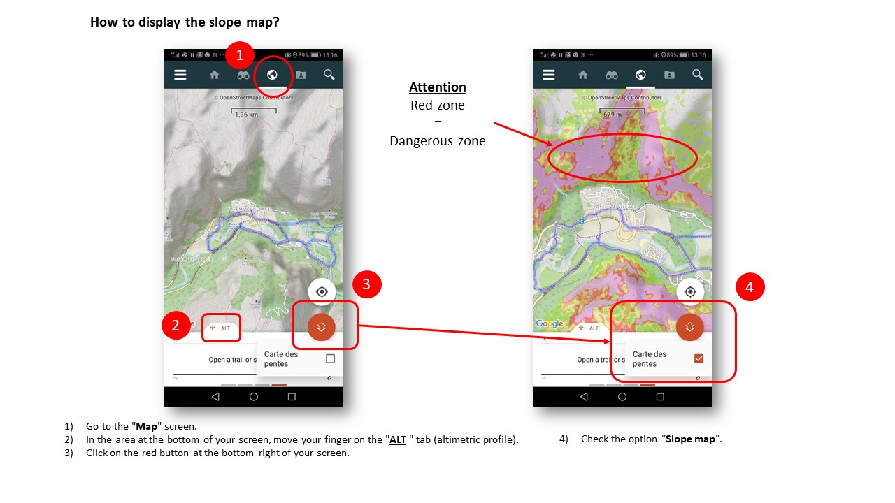
Zoom in the picture
1) Go to the "Map" screen.
2) In the area at the bottom of your screen, move your finger on the "ALT " tab (altimetric profile).
3) Click on the red button at the bottom right of your screen.
4) Check the option "Slope map".
How to display the slope map ? 
1) Go to the "Map" screen.
2) In the area at the bottom of your screen, move your finger on the "ALT " tab (altimetric profile).
3) Click on the red button at the bottom right of your screen.
4) Check the option "Slope map".
How to know is a map has been successfully downloaded ? 
1) Open the main menu via this icon :
2) Select the "Download maps" tab.
3) All zones present are predefined geographic areas.
4) You can from, from an area, request the details page and request also an update of the maps.
How to know if a map has been successfully downloaded?
1) Open the main menu via this icon :
2) Select the "Download maps" tab.
3) All zones present are predefined geographic areas.
4) You can from, from an area, request the details page and request also an update of the maps.
What types of maps are available on the app?
It is possible to select different types of maps when downloading zone. The different maps available are: OpenStreetMap, Sitytrail Topo World, IGN France - Topographic Map, IGN France - Classic SCAN Express, IGN France - Standard SCAN Express, IGN France - aerial photos, IGN France - cadastral parcels, IGN France - Relief.
Important information
Information for In App Purchases via Apple
Terms of use
Privacy Policy